英文互译镜像站

Rural Municipality of White Valley No. 49

Last updated

White Valley No. 49
Rural Municipality of White Valley No. 49
Farwell Creek SD 4267, Saskatchewan.jpg
The abandoned Farwell Creek school
SK RM 49 White Valley.svg
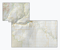
Location of the RM of White Valley No. 49 in Saskatchewan
Coordinates: 49°36′04″N109°04′19″W / 49.601°N 109.072°W / 49.601; -109.072 [1]
Country Canada
Province Saskatchewan
Census division 4
SARM division 3
Federal riding Cypress Hills—Grasslands
Provincial riding Cypress Hills
Formed [2] January 1, 1913
Government
[3]
   Reeve James Leroy
  Governing bodyRM of White Valley No. 49 Council
  AdministratorTracey Schacher
  Office location Eastend
Area
 (2016) [4]
  Land2,026.88 km2 (782.58 sq mi)
Population
 (2021) [4]
  Total
352
  Density0.2/km2 (0.5/sq mi)
Time zone CST
  Summer (DST) CST
Postal code
S0N 0T0
Area codes 306 and 639
Highway(s) Highway 13
Highway 633
Highway 614
Waterway(s) Frenchman River

The Rural Municipality of White Valley No. 49 (2016 population: 478) is a rural municipality (RM) in the Canadian province of Saskatchewan within Census Division No. 4 and SARM Division No. 3. It is located in the southwest portion of the province near Eastend.

Contents

History

The RM of White Valley No. 49 incorporated as a rural municipality on January 1, 1913. [2]

Geography

Communities and localities

The following urban municipalities are surrounded by the RM.

Towns

The following unincorporated communities are within the RM.

Localities [5]

Demographics

Population history
(1981–2016)
YearPop.±%
1981731    
1986674−7.8%
1991641−4.9%
1996 615−4.1%
2001 570−7.3%
2006 518−9.1%
2011 478−7.7%
2016 478+0.0%
2021 352−26.4%
Source: Statistics Canada via Saskatchewan Bureau of Statistics [6] [7]

In the 2021 Census of Population conducted by Statistics Canada, the RM of White Valley No. 49 had a population of 352 living in 146 of its 182 total private dwellings, a change of

In the 2016 Census of Population, the RM of White Valley No. 49 recorded a population of 478 living in 155 of its 195 total private dwellings, a

Government

The RM of White Valley No. 49 is governed by an elected municipal council and an appointed administrator that meets on the second Thursday of every month. [3] The reeve of the RM is James Leroy while its administrator is Tracey Schacher. [3] The RM's office is located in Eastend. [3]

Transportation

HighwayStarting pointCommunitiesEnding point
Highway 13 Alberta Highway 501 Eastend Manitoba Highway 3
Highway 614 Loomis Eastend Piapot
Highway 633 Highway 13 South Fork Saskatchewan Highway 332

See also

References

  1. "Pre-packaged CSV files - CGN, Canada/Province/Territory (cgn_sk_csv_eng.zip)". Government of Canada. July 24, 2019. Retrieved May 23, 2020.
  2. 1 2 "Rural Municipality Incorporations (Alphabetical)". Saskatchewan Ministry of Municipal Affairs. Archived from the original on April 21, 2011. Retrieved May 9, 2020.
  3. 1 2 3 4 "Municipality Details: RM of White Valley No. 49". Government of Saskatchewan. Retrieved May 21, 2020.
  4. 1 2 3 "Population and dwelling counts, for Canada, provinces and territories, and census subdivisions (municipalities), 2016 and 2011 censuses – 100% data (Saskatchewan)". Statistics Canada. February 8, 2017. Retrieved May 1, 2020.
  5. Standard Geographical Classification (SGC) 2001
  6. "Saskatchewan Census Population" (PDF). Saskatchewan Bureau of Statistics. Archived from the original (PDF) on September 24, 2015. Retrieved May 9, 2020.
  7. "Saskatchewan Census Population". Saskatchewan Bureau of Statistics. Retrieved May 9, 2020.
  8. "Population and dwelling counts: Canada, provinces and territories, census divisions and census subdivisions (municipalities), Saskatchewan". Statistics Canada. February 9, 2022. Retrieved April 13, 2022.
时间因子转换镜像 批量镜像网站 MirrorElf 镜像站群系统 超级站群助手