This article includes a list of references, related reading, or external links, but its sources remain unclear because it lacks inline citations .(November 2019) |
Royal Township | |
|---|---|
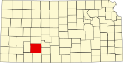
 Location in Ford County | |
| Coordinates: 37°52′12″N100°07′05″W / 37.87000°N 100.11806°W | |
| Country | United States |
| State | Kansas |
| County | Ford |
| Area | |
• Total | 71.64 sq mi (185.54 km2) |
| • Land | 71.59 sq mi (185.43 km2) |
| • Water | 0.042 sq mi (0.11 km2) 0.06% |
| Elevation | 2,615 ft (797 m) |
| Population (2000) | |
• Total | 105 |
| • Density | 1.6/sq mi (0.6/km2) |
| GNIS feature ID | 0471628 |
Royal Township is a township in Ford County, Kansas, United States. As of the 2000 census, its population was 105.