英文互译镜像站

Greenwood, Queensland

Last updated

Greenwood
St Paul's Lutheran Church, Greenwood, 2006 01.jpg
St Paul's Lutheran Church, Greenwood, 2006
Australia Queensland location map.svg
Red pog.svg
Greenwood
Greenwood, Queensland
Interactive map of Greenwood
Coordinates: 27°20′12″S151°44′23″E / 27.3366°S 151.7397°E / -27.3366; 151.7397 (Greenwood (centre of locality))
Country Australia
State Queensland
LGA
Location
Government
   State electorate
   Federal division
Area
  Total
17.4 km2 (6.7 sq mi)
Population
  Total34 (2021 census) [1]
  Density1.95/km2 (5.06/sq mi)
Time zone UTC+10:00 (AEST)
Postcode
4401
Suburbs around Greenwood
Acland Silverleigh Silverleigh
Acland Greenwood Silverleigh
Sabine Kelvinhaugh Kelvinhaugh

Greenwood is a rural locality in the Toowoomba Region, Queensland, Australia. [2] In the 2021 census, Greenwood had a population of 34 people. [1]

Contents

Geography

The Oakey–Cooyar Road enters from the south-west (Sabine / Kelvinhaugh) and forms the south-west boundary of the locality before continuing north through the locality, exiting to the north (Silverleigh). [3] [4]

Greenwood has the following mountains:

The land is freehold and used for agriculture, predominantly crop growing with some grazing on native vegetation. [8]

History

A Lutheran congregation formed in 1899 and in November 1890 opened St Paul's Lutheran Church. In 1991, due to differences of opinion on religious issues, the church separated from the Lutheran Church of Australia and, in 1992, joined with a number of other like-minded Lutheran congregations to form the Australian Evangelical Lutheran Church. [9] [10]

The first Evangelical Lutheran Church in Queensland opened at Greenwood circa 1900. However, the Greenwood congregation outgrew the building so it was relocated to Yamsion to become its Evangelican Lutheran Church, where it was officially opened and dedicated on Thursday 18 May 1922. [11]

Greenwood Provisional School opened in June 1907. [12] [13] On 1 January 1909, it became Greenwood State School. It closed in 1968. [14] It was at 1091 Oakey Cooyar Road (corner of Greenwood School Road, 27°20′16″S151°43′45″E / 27.3379°S 151.7293°E / -27.3379; 151.7293 (Greenwood State School (site)) ). [15] [16] [17]

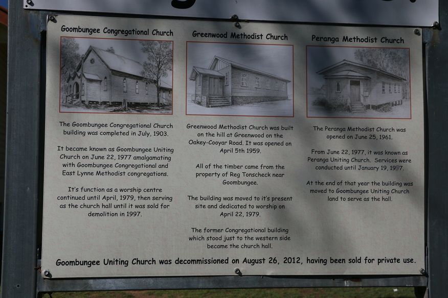
Greenwood Methodist Church opened on 5 April 1959 at the top of the hill on Oakey-Cooyar Road, becoming the Greenwood Uniting Church after the 1977 amalgamation which formed the Uniting Church in Australia. In 1979, the Greenwood church building was relocated to Goombungee to become the Goombungee Uniting Church, while the former Goombungee Uniting Church became the church hall. On 26 August 2012, the former Greenwood church in Goombungee was decommissioned as a church and sold into private ownership. [18] [19]

Demographics

In the 2016 census, Greenwood had a population of 40 people. [20]

In the 2021 census, Greenwood had a population of 34 people. [1]

Education

There are no schools in Greenwood. The nearest government primary schools are Oakey State School in Oakey to the south and Goombungee State School in Goombungee to the north-east. The nearest government secondary school is Oakey State High School in Oakey to the south. There is also a Catholic primary school in Oakey. [21]

Amenities

Despite the name, St Paul's Lutheran Church, Greenwood, is at 617 Acland Silverleigh Road in Silverleigh ( 27°18′53″S151°44′57″E / 27.31461°S 151.74926°E / -27.31461; 151.74926 (St Paul's Lutheran Church, Greenwood) ). [22]

References

  1. 1 2 3 Australian Bureau of Statistics (28 June 2022). "Greenwood (SAL)". 2021 Census QuickStats. Retrieved 28 February 2023. OOjs UI icon edit-ltr-progressive.svg
  2. "Greenwood – locality in Toowoomba Region (entry 47960)". Queensland Place Names. Queensland Government . Retrieved 29 December 2020.
  3. Greenwood, Queensland (Map). OpenStreetMap. Archived from the original on 18 January 2022. Retrieved 18 January 2022.
  4. "Layers: Locality; Road and rail; Railways; Railway stations". Queensland Globe. Queensland Government. Archived from the original on 19 December 2017. Retrieved 8 February 2025.
  5. 1 2 "Mountain peaks and capes - Queensland". Queensland Open Data. Queensland Government. 12 November 2020. Archived from the original on 25 November 2020. Retrieved 25 November 2020.
  6. "Boah Peak – mountain in Toowoomba Region (entry 3364)". Queensland Place Names. Queensland Government . Retrieved 25 November 2020.
  7. "Turkey Hill – mountain in Toowoomba Region (entry 35371)". Queensland Place Names. Queensland Government . Retrieved 25 November 2020.
  8. "Layers: Locality; Protected areas and forests; Land use; Sugarcane areas". Queensland Globe. Queensland Government. Archived from the original on 19 December 2017. Retrieved 8 February 2025.
  9. "About Greenwood St Paul's". Australian Evangelical Lutheran Church. Retrieved 16 September 2022.
  10. "St Paul's Lutheran Church | Silverleigh". Queensland Religious Places Database. Archived from the original on 24 July 2024. Retrieved 9 February 2025.
  11. "DALBY". The Brisbane Courier . No. 20, 070. Queensland, Australia. 19 May 1922. p. 8. Retrieved 27 February 2021 via National Library of Australia.
  12. "New Provisional School". The Telegraph . No. 10, 637. Queensland, Australia. 20 December 1906. p. 3 (SECOND EDITION). Retrieved 8 February 2025 via National Library of Australia.
  13. "DOWNS NEWS". Darling Downs Gazette . Vol. XLIX, no. 8, 031. Queensland, Australia. 7 June 1907. p. 8. Retrieved 8 February 2025 via National Library of Australia.
  14. Queensland Family History Society (2010), Queensland schools past and present (Version 1.01 ed.), Queensland Family History Society, ISBN   978-1-921171-26-0
  15. "Parish of King County of Aubigny" (Map). Queensland Government. 1942. Archived from the original on 17 December 2020. Retrieved 17 December 2020.
  16. "Queensland Two Mile series sheet 2m44" (Map). Queensland Government. 1941. Retrieved 8 February 2025.
  17. "Layers: Locality; Road and rail; Land parcel". Queensland Globe. Queensland Government. Archived from the original on 19 December 2017. Retrieved 8 February 2025.
  18. "Noticeboard outside Goombungee Uniting Church, 6 George Street". Churches Australia. Archived from the original on 17 December 2020. Retrieved 17 December 2020.
  19. "Goombungee Uniting Church - Former". Churches Australia. Archived from the original on 17 December 2020. Retrieved 17 December 2020.
  20. Australian Bureau of Statistics (27 June 2017). "Greenwood (SSC)". 2016 Census QuickStats. Retrieved 20 October 2018. OOjs UI icon edit-ltr-progressive.svg
  21. "Layers: Locality; Schools and school catchments". Queensland Globe. Queensland Government. Archived from the original on 19 December 2017. Retrieved 8 February 2025.
  22. Blake, Thom. "St Paul's Lutheran Church". Queensland religious places database. Retrieved 16 September 2022.

Further reading

英文互译镜像站 一键镜像站群 站点克隆软件 网站备份克隆 整站下载器