You can help expand this article with text translated from the corresponding article in French. (December 2008)Click [show] for important translation instructions.
|
Fontaine-Uterte | |
|---|---|
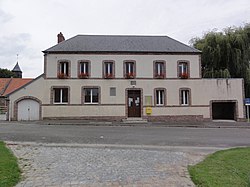 The town hall and school of Fontaine-Uterte | |
 Location of Fontaine-Uterte | |
 Fontaine-Uterte  Fontaine-Uterte | |
| Coordinates: 49°55′19″N3°22′12″E / 49.9219°N 3.37°E | |
| Country | France |
| Region | Hauts-de-France |
| Department | Aisne |
| Arrondissement | Saint-Quentin |
| Canton | Bohain-en-Vermandois |
| Intercommunality | Pays du Vermandois |
| Government | |
| • Mayor (2020–2026) | Patrick Michalak [1] |
Area 1 | 5.77 km2 (2.23 sq mi) |
| Population (2023) [2] | 140 |
| • Density | 24/km2 (63/sq mi) |
| Time zone | UTC+01:00 (CET) |
| • Summer (DST) | UTC+02:00 (CEST) |
| INSEE/Postal code | 02323 /02110 |
| Elevation | 98–144 m (322–472 ft) (avg. 145 m or 476 ft) |
| 1 French Land Register data, which excludes lakes, ponds, glaciers > 1 km2 (0.386 sq mi or 247 acres) and river estuaries. | |
Fontaine-Uterte is a commune in the Aisne department in Hauts-de-France in northern France.