You can help expand this article with text translated from the corresponding article in German. (October 2017)Click [show] for important translation instructions.
|
Ziersdorf | |
|---|---|
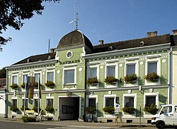 Town hall | |
 Coat of arms | |
 Ziersdorf Location within Austria | |
| Coordinates: 48°32′N15°56′E / 48.533°N 15.933°E | |
| Country | Austria |
| State | Lower Austria |
| District | Hollabrunn |
| Government | |
| • Mayor | Ing. Hermann Fischer |
| Area | |
• Total | 48.71 km2 (18.81 sq mi) |
| Elevation | 230 m (750 ft) |
| Population (2018-01-01) [2] | |
• Total | 3,446 |
| • Density | 71/km2 (180/sq mi) |
| Time zone | UTC+1 (CET) |
| • Summer (DST) | UTC+2 (CEST) |
| Postal code | 3710 |
| Area code | 02956 |
| Website | www.ziersdorf.at |
Ziersdorf is a town in the district of Hollabrunn in Lower Austria, Austria.