
The Chestnut Hill Reservoir Historic District is a historic district encompassing the Chestnut Hill Reservoir and the surrounding water works facilities which were historically used to provide fresh water to Boston, Massachusetts, and surrounding towns. The district is nearly coextensive with the Chestnut Hill Reservation, a state park managed by the Massachusetts Department of Conservation and Recreation (DCR); those elements of the water works that are still required as an emergency backup are managed by the Massachusetts Water Resources Authority (MWRA). The reservoir is located between Beacon Street and Commonwealth Avenue in Boston's Chestnut Hill district, just east of the Boston College Main Campus Historic District.

The Brandegee Estate is a historic estate at 280 Newton Street in Brookline and Boston, Massachusetts. Developed at the turn of the 20th century, it is one of the largest essentially intact estate properties in either community. It was developed by Mary (Pratt) Sprague, a direct descendant of Joseph Weld, one of Boston's first settlers, and is noted for its large Renaissance Revival mansion, and landscaping by Charles A. Platt. The estate was listed on the National Register of Historic Places in 1985. Its name derives from Mary Sprague's second husband, Edward Brandegee.

The Salem–Auburn Streets Historic District is a residential historic district at Salem and Auburn Streets in Cambridge, Massachusetts. The district includes a collection of houses that is among the oldest in the Cambridgeport section of the city, and includes most of the houses on two blocks of these streets. The district was added to the National Register of Historic Places in 1982.

Saint Aidan's Church and Rectory is a historic Catholic church complex in Brookline, Massachusetts. The stuccoed church, located at 224-210 Freeman Street, was designed by Maginnis & Walsh, a noted designer of ecclesiastical buildings, in the Medieval (Tudor) Revival style, and was built in 1911. It was Brookline's third Catholic parish, after Saint Mary's and Saint Lawrence. The church is notable as the parish which was attended by Joseph P. Kennedy and his family when they were living on Beals Street; it was the site of the baptism of both John F. Kennedy and Robert F. Kennedy. The rectory, located at 158 Pleasant Street, was built c. 1850-55 by Edward G. Parker, a Boston lawyer. It was acquired by the church in 1911, and restyled to match the church in 1920.

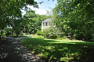
The Benjamin White House is a historic house at 203 Heath Street in Brookline, Massachusetts. Built in 1790, this two-story wood-frame house is one of the oldest on Heath Street. It has been moved twice: once when the Cabot family established a large estate in the area, at which time they moved it back from Heath Street and added a barn, and again in 1947, when the barn was demolished and the house moved onto its foundation. Much of the interior finish was lost during interior remodelling in the 1940s, but the exterior has retained much of its 18th and 19th century trim.

The Beaconsfield Terraces Historic District is a residential historic district at 11–25, 33–43, and 44–55 Garrison Rd. and 316–326, 332–344, and 350–366 Tappan Street in Brookline, Massachusetts. It encompasses a collection of architecturally distinctive row houses that were built between 1889 and 1892 by a single developer, and represent a unique early success in condominium ownership. The district was listed on the National Register of Historic Places in 1985.

The Brookline Town Green Historic District encompasses the historic colonial heart of the town of Brookline, Massachusetts. Centered on a stretch of Walnut Street between Warren and Chestnut Streets, this area is where the town's first colonial meeting house and cemetery were laid out, and was its center of civic life until the early 19th century. The district was listed on the National Register of Historic Places in 1980.

The Building at 30–34 Station Street in Brookline, Massachusetts, is a historic mixed-use residential/commercial building. It was designed by architects Winslow & Wetherell with elements of Colonial Revival and Georgian Revival style, and was completed in 1893. It is one of the first examples in Brookline of a mixed-use building. It was listed on the National Register of Historic Places in 1985.
The Timothy Corey House No. 1 is a historic house at 808 Washington Street in Brookline, Massachusetts. Built in 1806, it is a good example of vernacular Federal architecture, and was home for over a century to members of one of the town's most prominent early families. The house was listed on the National Register of Historic Places in 1985.

The Cypress–Emerson Historic District encompasses a residential area on the west side of Brookline Village in Brookline, Massachusetts, United States. Centered on Waverly and Cypress Streets, and including Emerson Park, this area was developed in the post-Civil War era, its growth matching that of the commercial areas of the village. The district was listed on the National Register of Historic Places in 1985.

The Robert S. Davis House is a historic house at 50 Stanton Road in Brookline, Massachusetts. Built about 1859 for the scion of a locally prominent family, it is one of the town's best-preserved examples of Italianate architecture. It was listed on the National Register of Historic Places in 1985.
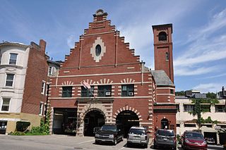
Fire Station No. 7, also known as the Washington Square Station, is a historic fire station at 665 Washington Street in Brookline, Massachusetts. Built in 1898, it is an architecturally eclectic mix of Dutch and Renaissance Revival styles. The building was listed on the National Register of Historic Places in 1985. It presently houses Engine 3 and a paramedic ambulance.

The Fisher Hill Reservoir and Gatehouse are historic elements of the public water supply for the Greater Boston area.
The Graffam Development Historic District is a residential area located in the American town of Brookline, Massachusetts. It encompasses the best-preserved portion of a historic residential subdivision, platted and built between 1894 and 1907. The land was purchased by Peter Graffam, who built a variety of Queen Anne and Colonial Revival houses on Babcock Street, Abbottsford Road, Manchester Road, Stedman Street, and Naples Road in Brookline, Massachusetts. Graffam also developed Osborne Street, but most of its houses have since been modified, losing historic integrity. The district was listed on the National Register of Historic Places in 1985.

4 Perry Street is a historic house in Brookline, Massachusetts, USA. It is locally significant as a well-preserved local example of Greek Revival styling.

The Thaddeus Jackson House is a historic house at 15 Alberta Road in Brookline, Massachusetts. Built in 1820, it is one of Brookline's older surviving houses, unusual because it was built in the Georgian style, then already out of fashion. The house was listed on the National Register of Historic Places on October 17, 1985.

Reservoir Park is a historic park on Boylston Street in Brookline, Massachusetts. Its principal feature is Brookline Reservoir, formerly an element of the public water supply for neighboring Boston.

Saint Mary of the Assumption Church, Rectory, School and Convent is a historic church complex at 67 Harvard Street, and 3 and 5 Linden Place, in Brookline, Massachusetts in the Archdiocese of Boston. It was the first Roman Catholic Church in Brookline, and the first in the nation to bear the name. Most of its buildings were built between 1880 and 1906, and are reflective of the growth of the area's Irish immigrant community during that time. The complex was listed on the National Register of Historic Places in 1985.

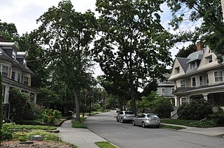
The Strathmore Road Historic District is a residential historic district on Strathmore Road and Clinton Path in Brookline, Massachusetts. It consists of six brick apartment blocks, four of which lie on Strathmore Road, and two of which lie on Clinton Path. The two streets form a loop just south of the westernmost portion of Beacon Street, and abutting the MBTA Green Line yard at Cleveland Circle. The district is reflective of the area's growth as a commuter suburb following the development of the rail line along Beacon Street, and was listed on the National Register of Historic Places in 1985.

West Roxbury Parkway is a historic parkway running from Washington Street in Boston, Massachusetts, where the Enneking Parkway runs south, to Horace James Circle in Chestnut Hill, where it meets the Hammond Pond Parkway. The parkway serves as a connector between Stony Brook Reservation and Hammond Pond Reservation. West Roxbury Parkway was built between 1919 and 1929 and added to the National Register of Historic Places in 2006. The parkway is distinctive in the roadway system developed by the Metropolitan District Commission beginning around the turn of the 20th century in that it was built in collaboration with the City of Boston, and is maintained by the city.


