Weirton Heights, West Virginia | |
|---|---|
 Weirton Heights | |
| Coordinates: 40°24′30″N80°32′21″W / 40.40833°N 80.53917°W | |
| Country | United States |
| State | West Virginia |
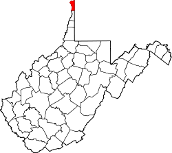
| County | Hancock |
| Elevation | 1,197 ft (365 m) |
| Time zone | UTC-5 (Eastern (EST)) |
| • Summer (DST) | UTC-4 (EDT) |
| GNIS ID | 1555933 [1] |
Weirton Heights is a neighborhood of Weirton, West Virginia, United States.
Weirton Heights is located along WV 105 east of downtown Weirton.
Weirton Heights was incorporated in 1938, and was named for steel manufacturer Ernest T. Weir. [2]