Watkins, Illinois | |
|---|---|
 Watkins  Watkins | |
| Coordinates: 40°16′51″N88°40′38″W / 40.28083°N 88.67722°W | |
| Country | United States |
| State | Illinois |
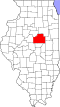
| Counties | DeWitt and McLean |
| Elevation | 745 ft (227 m) |
| Time zone | UTC-6 (Central (CST)) |
| • Summer (DST) | UTC-5 (CDT) |
| Area code | 217 |
| GNIS feature ID | 423292 [1] |
Watkins is an unincorporated community in DeWitt and McLean counties, Illinois, United States.