Utleyville, Colorado | |
|---|---|
 Utleyville Post Office (1920s) | |
 Utleyville  Utleyville | |
| Coordinates: 37°16′16.06″N103°1′52.75″W / 37.2711278°N 103.0313194°W [1] | |
| Country | United States |
| State | Colorado |
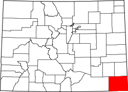
| County | Baca County |
| Elevation | 5,145 ft (1,568 m) |
| Time zone | UTC−7 (MST) |
| • Summer (DST) | UTC−6 (MDT) |
| ZIP Code | |
| Area code | 719 |
| FIPS code | 08-79985 [1] |
| GNIS ID | 196210 [1] |
Utleyville is an unincorporated community in Baca County, Colorado, United States. [1] It is approximately 32 driving miles west-southwest of Springfield. [3]