Unionville, Illinois | |
|---|---|
 Unionville, Illinois  Unionville, Illinois | |
| Coordinates: 40°01′30″N87°38′17″W / 40.02500°N 87.63806°W | |
| Country | United States |
| State | Illinois |
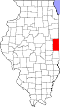
| County | Vermilion |
| Township | Georgetown |
| Elevation | 676 ft (206 m) |
| Time zone | UTC-6 (Central (CST)) |
| • Summer (DST) | UTC-5 (CDT) |
| Area code | 217 |
| GNIS feature ID | 420147 [1] |
Unionville is an unincorporated community in Georgetown Township, Vermilion County, Illinois, United States. Unionville is located on U.S. Route 150 and Illinois Route 1 along the southern border of Westville. [2]