This article has multiple issues. Please help improve it or discuss these issues on the talk page . (Learn how and when to remove these messages)
|
Twelvemile Corner, Illinois | |
|---|---|
 Twelvemile Corner  Twelvemile Corner | |
| Coordinates: 41°45′34″N89°05′00″W / 41.75944°N 89.08333°W | |
| Country | United States |
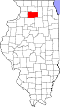
| State | Illinois |
| County | Lee |
| Township | Viola |
| Elevation | 784 ft (239 m) |
| Time zone | UTC-6 (Central (CST)) |
| • Summer (DST) | UTC-5 (CDT) |
| Area code(s) | 815 & 779 |
| GNIS feature ID | 419969 [1] |
Twelvemile Corner is an unincorporated community in Lee County, Illinois, United States. Twelvemile Corner is located at the intersection of U.S. Route 30 and Illinois Route 251, north of Compton.