英文互译镜像站

Southeast (Washington, D.C.)

Last updated

Southeast
Quadrant
DC satellite image.jpg
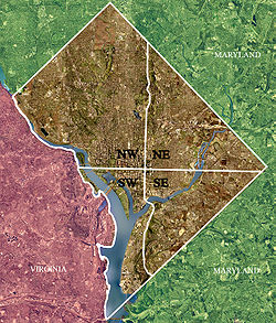
Color-enhanced USGS satellite image of Washington, D.C., taken April 26, 2002. The "crosshairs" in the image mark the quadrant divisions of Washington, with the U.S. Capitol at the center of the dividing lines. To the west of the Capitol extends the National Mall, visible as a thin green band in the image. The Northwest quadrant is the largest, located north of the Mall and west of North Capitol Street.
Southeast (Washington, D.C.)
Country Flag of the United States.svg United States
DistrictFlag of Washington, D.C.svg Washington, D.C.

Southeast (SE or S.E.) is the southeastern quadrant of Washington, D.C., the capital of the United States, and is located south of East Capitol Street and east of South Capitol Street. It includes the Capitol Hill, Hill East, and Anacostia neighborhoods, the Navy Yard, the Joint Base Anacostia-Bolling (JBAB), the U.S. Marine Barracks, the Anacostia River waterfront, Eastern Market, the remains of several Civil War-era forts, historic St. Elizabeths Hospital, RFK Stadium, Nationals Park, and the Congressional Cemetery. It also contains a landmark known as "The Big Chair," located on Martin Luther King Jr. Avenue. [1] The quadrant is split by the Anacostia River, with the portion that is west of the river sometimes referred to as "Near Southeast". Geographically, it is the second-smallest quadrant of the city.

Contents

The Yards Park at the Anacostia River Front SEDCanacostia.jpg
The Yards Park at the Anacostia River Front
Nationals Park and the Navy Yard neighborhood SEDCnats.jpg
Nationals Park and the Navy Yard neighborhood
RFK Stadium and the D.C. Armory looking towards the Hill East and Capitol Hill neighborhoods SEDCrfk.jpg
RFK Stadium and the D.C. Armory looking towards the Hill East and Capitol Hill neighborhoods
South Capitol St & Solar Panel Farm SEDCsolar.jpg
South Capitol St & Solar Panel Farm

Geography

Southeast includes the 32 neighborhoods of:

Government

Politically, Southeast includes most of Ward 8, as well as much of Ward 6 and Ward 7. Marion Barry, the former mayor of Washington, D.C., served as D.C. Council Member for Ward 8 until his death on November 23, 2014. [2] [3]

Culture

Nationals Park, the current ballpark for MLB's Washington Nationals, opened in the Navy Yard neighborhood in March 2008. [4] A $3.7 billion mixed-use stadium project to house the NFL's Washington Commanders is scheduled to open in the Hill East neighborhood in 2030. [5]

Transportation

Southeast Washington, D.C. is accessible via the Blue, Orange, Green and Silver Lines of the Washington Metro. [6]

Crime

In years past, the quadrant was known by some Washington, D.C. metropolitan area residents as being plagued by a high crime rate, relative to the rest of the city. [7]

Demographics

The population of Southeast is predominantly black. However, the African American population is concentrated southeast of the Anacostia River; the areas northwest of the Anacostia River are majority White. The portions of the quadrant southeast of the Anacostia are tree-lined and neighborly. However, shopping, dining, entertainment, and cultural options are limited, so some residents travel either downtown or to the suburbs for such services. There are several black middle class neighborhoods in Southeast, such as Hillcrest, Penn Branch, and Fort Dupont. The areas northwest of the Anacostia contains some of the wealthiest parts of the city, including the southern half of the famous and politically connected Capitol Hill neighborhood. Cultural events/activities include the annual Martin Luther King Jr. Birthday parade, the free weekly summer jazz concerts in Fort Dupont Park, the Fort Dupont ice-rink, the Anacostia Museum of the Smithsonian Institution, the Anacostia Arts Center, and THEARC tennis, arts and learning center for youth on Mississippi Avenue. The population of the southeast quadrant is roughly 226,084. [8]

Aerial view looking east SEWashingtonDC-0085-122122.jpg
Aerial view looking east
Anacostia River from Buzzard Point to the Navy Yard SEWashingtonDC-9808-120719.jpg
Anacostia River from Buzzard Point to the Navy Yard

See also

References

  1. Rolark Barnes, Denise. "Martin Luther King Avenue, Where Hope Lives". Washington Informer. Retrieved November 22, 2011.
  2. DePillis, Lydia (July 11, 2011). "Barry: No More Renters in Ward 8!". Washington City Paper. Retrieved November 22, 2011.
  3. Johnson, Darragh; Roberts, Roxanne (July 18, 2007). "Washington's Mayor for Life To Be Truly Immortalized – in Wax". The Washington Post. p. B01.
  4. Sandalow, Marc (March 1, 2008). "A Brand-New Ballgame: The New Stadium of the Nationals". Washingtonian. Retrieved November 22, 2011.
  5. Gathright, Jenny; Flynn, Meagan (September 18, 2025). "The Washington Commanders stadium is coming to D.C. Here's what to expect". The Washington Post . Retrieved September 22, 2025.
  6. "Metrorail Interactive Map". Metro - Rail - Maps - Rail/Google Map. WMATA. Archived from the original on June 3, 2010. Retrieved June 26, 2015.
  7. Layton, Lyndsey (August 3, 2003). "Metrobuses Face Rock Attacks On Streets of Southeast D.C." The Washington Post. Retrieved April 23, 2018.
  8. "Point 2 Homes". Southeast Washington D.C. Demographics & Statistics. Retrieved June 26, 2015.

38°52′N76°59′W / 38.87°N 76.98°W / 38.87; -76.98

一键镜像站群 时间因子转换镜像 蚂蚁超级镜像 霸屏SEO镜像站群 伪原创镜像站