Slatington Historic District | |
 751 Main St., Slatington, Pennsylvania | |
  | |
| Location | Roughly bounded by Ridge Alley, Chestnut St., Railroad St., Kern St., Hill Alley, 5th St. and Dowell, Slatington, Pennsylvania |
|---|---|
| Coordinates | 40°44′54″N75°36′43″W / 40.74833°N 75.61194°W |
| Area | 0 acres (0 ha) |
| NRHP reference No. | 04000839 [1] |
| Added to NRHP | August 11, 2004 |
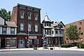
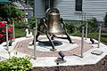
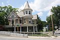
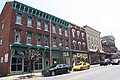
Slatington Historic District is a national historic district located at Slatington, Lehigh County, Pennsylvania. The district includes 506 contributing buildings and 2 contributing sites in the central business district and surrounding residential areas of Slatington. [2]
Contents
It was added to the National Register of Historic Places in 2004. [1]