The road signs of the Kingdom of the Netherlands (mainland Netherlands and six Dutch Caribbean islands) are regulated in the Reglement verkeersregels en verkeerstekens 1990, commonly abbreviated as RVV 1990.[1] While most old signs of RVV 1966 remained legal and official, they have been updated/replaced. Although some signs no longer have legal validity, most surviving old signs remain valid[2][3].
The history of Dutch traffic signs began in the late 19th century with the ANWB (founded 1883), which installed the first direction signs for cyclists in 1892 and by 1913 had shifted focus to automobile traffic[4]. The organization introduced the iconic concrete paddenstoel (mushroom) signs in 1919—designed by architect J.H.W. Leliman following a 1918 design competition, with the first twelve installed between Laren and Baarn. These distinctive signs were designed to be readable by cyclists looking down rather than up, allowing them to maintain speed and momentum without stopping.
The Netherlands also played a decisive role in the international effort to standardise road signs, a movement that began in the early 20th century and culminated in the visual language still recognised across Europe today. Early international efforts, such as the 1908 and 1926 World Road Congresses, focused on a limited set of warning signs for motorists[5]. The push for a more comprehensive system gained momentum with the League of Nations, leading to the pivotal 1931 Geneva Convention concerning the unification of road signs.
1931 Dutch proposal for universal road signs at the League of Nations.
During the negotiations, a significant controversy arose over the design of "no waiting" and "no parking" signs[6]. The preliminary draft proposed signs without the now-familiar diagonal stroke. The Dutch delegation, represented by G.F. Schönfeld, Administrator at the Dutch Ministry of Waterstaat (Rijkswaterstaat's predecessor), actively proposed alternative designs, including a round white sign with a red border and the letter 'P' for parking prohibition[7]. While this specific proposal was not adopted in its entirety, the matter was referred to a special sub-committee that ultimately forged a compromise[8]. Their final recommendation, which became part of the 1931 convention, introduced the diagonal red stroke as the key visual element for prohibition signs, alongside triangular signs for danger, round signs for prohibitions and obligations, and rectangular signs for information — a design feature that remains a global standard today[9].
Controversial parking sign of the 1930 Dutch proposal.
The Netherlands ratified this convention in 1934 with a five-year transition period for implementation[10]. The first comprehensive national regulations came with the Wegenverkeersregeling of 1941, which codified these principles in Dutch law and required all old signs to be replaced by December 1942[11]. An undated Dutch road atlas from around 1945 already featured a set of such signs, showing the early adoption and influence of these international standards within the Netherlands itself[12].
The foundations laid by the Netherlands and others in 1931 directly influenced the later, more comprehensive 1968 Vienna Convention on Road Signs and Signals[9], creating the broadly uniform European signing system that eventually effected designs globally.
C6: No access for motorised vehicles with more than two wheels.
C7: No access for trucks.
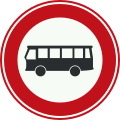
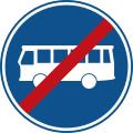
C7a: No access for buses.
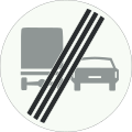
C7b: No access for buses and trucks.
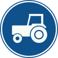
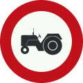
C8: No access for agricultural vehicles.
C9: No access for (horse) riders, livestock, wagons, agricultural and forestry tractors, motor vehicles with limited speed, mobile machines, microcars, bicycles, mopeds, scooters and mobility vehicles.
C10: No access for motor vehicle with towing trailers.
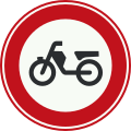
C11: No access for motorcycles.
C12: No access for all motorised vehicles.
C13: No access for mopeds, motor-assisted bicycles or motorised mobility vehicles.
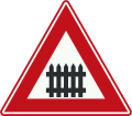
J11: Level crossing without barrier or gates ahead
J12: Level crossing with single track
J13: Level crossing with two or more tracks
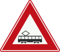
J14: Tram (crossing) ahead
J15: Opening or swing bridge ahead
J16: Road works ahead
J17: Road narrows on both sides
J18: Road narrows on the right side
J19: Road narrows on the left side
J20: Slippery road
J21: School crossing
J22: Pedestrian crossing
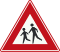
J23: Pedestrians
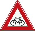
J24: Cyclists and moped riders
J25: Loose chippings
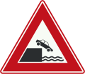
J26: Quayside or river bank
J27: Wild animals
J28: Domesticated animals
J29: Two-way traffic
J30: Low-flying aircraft
J31: Side winds
J32: Traffic lights
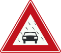
J33: Queues likely
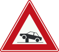
J34: Danger of accidents
J35: Reduced visibility because of snow, rain or fog
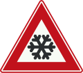
J36: Risk of ice or snow
J37: Other dangers
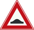
J38: Warning bump
J39: Warning for retractable bollard (poller) in the traffic lane that can be used to regulate access to streets and areas.
BB23-1: Level crossing distance board (close, each bar usually indicate 80 or 100m)
BB23-2: level crossing distance board (between, each bar usually indicate 80 or 100m)
BB23-3: level crossing distance board (far, each bar usually indicate 80 or 100m)
Series K: Wayfinding
While the Reglement verkeersregels en verkeerstekens 1990 (RVV 1990) regulates traffic rules and the majority of traffic signs in the Netherlands, directional signage for wayfinding (bewegwijzering) follows a separate set of guidelines. These signs are designed according to the "Richtlijn Bewegwijzering", a directive developed and maintained collaboratively by the Nationale Bewegwijzeringsdienst (NBd) and knowledge platform CROW[15]. The NBd is legally responsible for ensuring all directional sign plans in the country are consistent with this specific guideline, which covers everything from highway signs to cycling route wayfinding, to guarantee uniformity and reliability for all road users[16].
The following section displays the RVV version of such signage:
K1: Low level motorway information sign showing both main and intermediary destinations and the motorway number (old)
K2: Advance warning sign of a motorway showing the distance to the next exit and destinations after the exit (the top destination is the name of the exit), direction to aerodrome/airport and the road number (non-motorway)(old)
K3: Information sign for exit to motorway service area, showing the name of the rest area and symbols for the services offered (old)
K4: High level motorway information sign showing lane instructions for through traffic and exit panel showing intermediary destinations, with the motorway number and European route numbers (old)
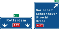
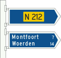
K5: Non-motorway advance information panel showing intermediary destinations, road numbers, a viaduct symbol and a sign for an industrial zone
K6: Non-motorway information panels showing intermediary destinations and non-motorway road numbers
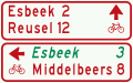
K7: Signposts for cyclists and moped riders (finger posts) showing local and intermediary destinations, municipal cycle route numbers (above) and showing intermediary destinations and intermediary cycle route numbers (below)
K8: Signposts (multiple) for cyclists and moped riders showing intermediary destinations and indicating an alternative route (in italics) to one of the destinations
K9: Diversion with alternative route shown on an advance warning panel for a non-motorway highway
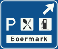
K10: Advance warning panel within a built-up area showing an intermediary destination, local destinations, local tourist sights, local facilities and road numbers through the town
K11: Lane instructions on a non-motorway highway. Panel showing intermediary destinations, road numbers and directions to a motorway
K12: Local signpost within a built-up area showing names of individual districts (in traffic areas)
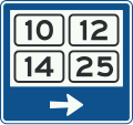
K13: Signpost within a built-up area showing district numbers (in traffic areas)
K14: Route for the conveyance of hazardous materials
The following are examples demonstrating those separate guidelines that is currently being used for the signs in practice:
K4 according to Rijkswaterstaat design guidelinesWayfinding signs on non-motorway (K6, K7 and K8) according to the Richtlijn Bewegwijzering 2025
L15: Hard shoulder equipped with emergency telephone and fire extinguisher
L16: Emergency telephone
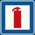
L17: Fire extinguisher
L18: Emergency telephone and fire extinguisher
L19: Nearest exit or second nearest exits in the directions and at the distances indicated on the sign
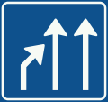
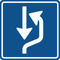
L20: Passing area on right-hand side of the road
L21: Passing area on left-hand side of the road
Road Barriers
Bilingual signage (Friesland)
In Friesland, a significant initiative is underway to introduce bilingual road signs featuring both Dutch and Frisian[19], responding to longstanding efforts to promote and make the minority language more visible in the public sphere[20]. This rollout, scheduled to begin in 2026 along provincial roads[21], follows the agreement between the national government and the province, which allocated €18 million for language preservation[22]. Many existing signs will be updated with stickers rather than being fully replaced, with old signs finding potential new homes in other provinces to reduce waste[23].
G13: bilingual version: optional cycle path
C2f + OB705: standard, Dutch only version: "go around", indicating no entry towards wrong-way drivers.
C2f + OB705: bilingual version, generally placed at ramps of controlled-access roads.
BB01: bilingual version: exit sign of controlled-access roads.
OB54 (sub-panel): bilingual version: exception of bikes and mopeds, commonly seen with access control signs at one-way streets.
Toll Road
The A24 (Blankenburgverbinding), which opened on 7 December 2024, is the first motorway in the Netherlands to implement electronic free-flow tolling (e-TOL) without traditional toll booths or barriers[24]. The 4.2-kilometre route connects the A15 at Rozenburg with the A20 at Vlaardingen via two tunnels—the Maasdeltatunnel and Hollandtunnel—and was built to improve accessibility in the Rotterdam port region[25]. Toll was introduced to finance the €1.168 billion construction cost, with charges of €1.51 for light vehicles and €9.13 for heavy vehicles, and the tolling is expected to continue for approximately 25 years until construction costs are recovered[26]. The system relies on ANPR cameras, requiring drivers to pay online within 72 hours of their journey or via automatic registration, a method that initially led to some payment compliance challenges as road users adapted to the new system[27].
Announcement of automatic toll collection (e-TOL)
Online payment reminder
Retired signs (RVV 1966)
Below, signs are withdrawn or replaced with new diagrams of the same meaning.
Priority
B1: Priority road (1941-1990)
B1: End of priority road (1941-1950)
B2: End of priority road (1950-1990)
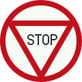
B7: Stop: Give way to traffic on the main road ahead (1950-1966)
B7: Stop: Give way to traffic on the main road ahead (1966-1979)
Prohibition and mandatory
C6: No access for vehicles with more than two wheels (1966-1990)
C7: No access for goods vehicles (1966-1990)
C8: No access for motor vehicles that cannot exceed 25km/h (1966-1990)
Suriname—as a former Dutch colony—base their signage designs on those used in the Netherlands (RVV 1990). However, some pictograms are mirrored horizontally to accommodate their left-hand traffic system.
This page is based on this Wikipedia article Text is available under the CC BY-SA 4.0 license; additional terms may apply. Images, videos and audio are available under their respective licenses.