Pyramid, Illinois | |
|---|---|
 Pyramid, Illinois  Pyramid, Illinois | |
| Coordinates: 38°20′03″N89°13′40″W / 38.33417°N 89.22778°W | |
| Country | United States |
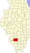
| State | Illinois |
| County | Washington |
| Township | Ashley |
| Elevation | 561 ft (171 m) |
| Time zone | UTC-6 (Central (CST)) |
| • Summer (DST) | UTC-5 (CDT) |
| Area code | 618 |
| GNIS feature ID | 423095 [1] |
Pyramid (also known as Tuckerville [2] ) is an unincorporated community in Ashley Township, Washington County, Illinois, United States. [1] The community is located at the junction of U.S. Route 51 and Illinois Route 15. [2] It was once the site of the Egyptian Bus Company, which was later bought by Greyhound. [3]