Ngawi (pronounced "ngaa-wee") is a small fishing / holiday village within five kilometres of Cape Palliser, the southern-most point of New Zealand's North Island.
The area is popular with commercial and recreational fishermen. The fishery includes pāua (a type of abalone which is prized for its iridescent shell as well as the flesh), crayfish, and cod.
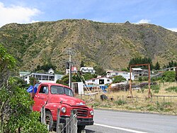
Ngawi has more bulldozers per capita than anywhere else.[2] The bulldozers are used to haul fishing boats into and out of the water[3] as there is no wharf or other access to the ocean other than the beach, which can be notoriously rough.[4]Crayfish (also known as rock lobster) are caught commercially for live export.[3] In 2011, there were around a dozen commercial fishermen working from Ngawi, but most did not live in the village.[5]
The village comprises mainly small wooden houses, called baches. The population is much larger during the summer season, when all the holiday homes are occupied.[5] There are no shops in Ngawi, and the nearest school is at Pirinoa, around 37.5 kilometres (23.3mi) to the north.[5]
Ngawi is situated on the southern coast of New Zealand’s North Island in the Palliser Bay region, near the southernmost point at Cape Palliser. The village lies along an exposed stretch of coastline that faces the Cook Strait, meaning it is regularly battered by strong winds and southerly swells. The shore here consists of steep gravel and cobble beaches, backed by a narrow coastal plain of mixed marine and alluvial gravels and flanked by rugged hillsides inland. The vegetation is sparse and mainly hardy coastal grassland and shrubland adapted to the salty winds and rough conditions. Due to its coastal exposure and dynamic environment, coastal erosion and shifting shorelines are ongoing features of the landscape.[6][7]
Ngawi’s marine environment supports diverse wildlife; just a few kilometres along the coast at Cape Palliser is one of the largest fur seal colonies in the North Island, a prominent part of the local ecosystem that draws seasonal wildlife interest. The coastal waters and reefs also sustain important fish species like paua (abalone) and crayfish, which have shaped the village’s fishing heritage.[8][9]
The combination of powerful ocean conditions, clear coastal views, and minimal tree cover gives Ngawi a distinctive wild and open coastal character that contrasts with more sheltered parts of New Zealand’s shoreline.
Ngawi’s heritage is tied closely to the broader history of the Palliser Bay area, which was inhabited by Māori communities from around the late 1300s. Archaeological research shows that early Māori people occupied the coastal strip east of Palliser Bay in several small settlements, cultivating kūmara (sweet potato) and other crops, fishing from the sea, and gathering shellfish (leaving behind features like stone walls and midden deposits that indicate long-term use of the land and sea resources). Many parts of the coastline near Ngawi, including Kainga and pā sites, are still recognized for their cultural significance to Māori.[11][12]
For Māori, the wider Cape Palliser region (very near Ngawi) is also associated with traditions about the great Polynesian explorer Kupe, whose journeys across Aotearoa (New Zealand) are celebrated in local place names and stories.[12]
European settlement in the South Wairarapa region began in the mid-1800s, with pastoral farming becoming established on much of the cleared land. Within this context, Ngawi itself developed as a small commercial fishing base, taking advantage of the abundant kaimoana (seafood) such as crayfish and pāua along the exposed Cook Strait coast. Although the village never grew into a large town, it became known for its robust fishing community and its distinctive practice of using bulldozers and tractors to launch boats straight from the beach due to the absence of a sheltered harbour (a local custom that reflects the rugged working culture of the settlement).[8][13]
In May 2006, filmmaker Peter Salmon shot a short film called 'Fog' in Ngawi. Salmon was drawn to the area's unique landscape and isolated feel. 'Fog' premiered at Critic's Week at the Cannes Film Festival in 2007. It stars Joe Dekkers-Reihana, Chelsie Crayford Preston, Jim Moriarty and Tina Cook.[14]
This page is based on this Wikipedia article Text is available under the CC BY-SA 4.0 license; additional terms may apply. Images, videos and audio are available under their respective licenses.