Milfay, Oklahoma | |
|---|---|
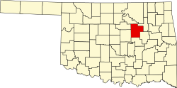
 Milfay Location within the state of Oklahoma  Milfay Milfay (the United States) | |
| Coordinates: 35°45′06″N96°33′33″W / 35.75167°N 96.55917°W | |
| Country | United States |
| State | Oklahoma |
| County | Creek |
| Area | |
• Total | 0.64 sq mi (1.66 km2) |
| • Land | 0.63 sq mi (1.64 km2) |
| • Water | 0.0039 sq mi (0.01 km2) |
| Elevation | 837 ft (255 m) |
| Population (2020) | |
• Total | 74 |
| • Density | 116.8/sq mi (45.11/km2) |
| Time zone | UTC-6 (Central (CST)) |
| • Summer (DST) | UTC-5 (CDT) |
| FIPS code | 40-48450 |
| GNIS feature ID | 2805341 [2] |
Milfay is a small unincorporated community in Creek County, Oklahoma, United States, about five and a half miles east of Stroud. [3] The post office was established December 14, 1911. The community was named after Charles Mills and Edward Fay, two railroad officials. [4]