英文互译镜像站

Jefferson Davis County, Mississippi

Last updated

Jefferson Davis County, Mississippi
County
Jefferson Davis County Mississippi Courthouse.jpg
Map of Mississippi highlighting Jefferson Davis County.svg
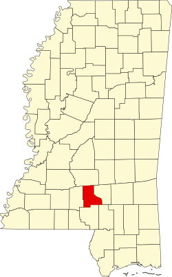
Location within the U.S. state of Mississippi
Coordinates: 31°34′N89°49′W / 31.56°N 89.82°W / 31.56; -89.82
CountryFlag of the United States.svg United States
StateFlag of Mississippi.svg Mississippi
Founded1906
Named after Jefferson Davis
Seat Prentiss
Largest townPrentiss
Area
  Total
409 sq mi (1,060 km2)
  Land408 sq mi (1,060 km2)
  Water0.7 sq mi (1.8 km2)  0.2%
Population
 (2020)
  Total
11,321
  Density27.7/sq mi (10.7/km2)
Time zone UTC−6 (Central)
  Summer (DST) UTC−5 (CDT)
Congressional district 3rd
Website www.jeffersondaviscountyms.com

Jefferson Davis County is a county located in the U.S. state of Mississippi. As of the 2020 census, the population was 11,321. [1] Its county seat is Prentiss. [2] The county is named after Mississippi Senator and Confederate President Jefferson Davis. The county was carved out of Covington and Lawrence counties in March 1906. Governor James K. Vardaman signed the bill creating the county on May 9, 1906.

Contents

History

The genesis of the county occurred on March 31, 1906, when a Mississippi state legislative act authorized the new country's boundaries. The residents of western Covington County and eastern Lawrence County had frequently complained of the rivers and streams impeding the route to their respective county seats. Jefferson Davis County was the state's 77th county.

A 1906 special referendum determined that the county seat would be Prentiss, named for either famed Mississippi lawmaker and orator Seargent Smith Prentiss, or wealthy landowner Prentiss Webb Berry. The settlement was originally named Blountville after early settler William Blount.

In 1933, the county was the first in Mississippi to issue a prohibition on alcohol after the repeal of the Eighteenth Amendment to the United States Constitution. Round dancing in the community hall was banned in 1938.

In 1935, notorious bank robber Raymond Hamilton, known to hide out in the county's wilderness, was involved in a hostage situation after robbing Prentiss' Bank of Blountville, but escaped in Memphis. [3]

Geography

According to the U.S. Census Bureau, the county has a total area of 409 square miles (1,060 km2), of which 408 square miles (1,060 km2) is land and 0.7 square miles (1.8 km2) (0.2%) is water. [4]

Major highways

Adjacent counties

Demographics

Historical population
CensusPop.Note
1910 12,860
1920 12,755−0.8%
1930 14,28112.0%
1940 15,86911.1%
1950 15,500−2.3%
1960 13,540−12.6%
1970 12,936−4.5%
1980 13,8467.0%
1990 14,0511.5%
2000 13,962−0.6%
2010 12,487−10.6%
2020 11,321−9.3%
2024 (est.)11,059 [5] Decrease2.svg−2.3%
U.S. Decennial Census [6]
1790-1960 [7] 1900-1990 [8]
1990-2000 [9] 2010-2013 [10]

Racial and ethnic composition

Jefferson Davis County racial composition as of 2020 [11]
RaceNum.Perc.
White (non-Hispanic)4,33038.25%
Black or African American (non-Hispanic)6,62258.49%
Native American 80.07%
Asian 210.19%
Other/Mixed 2392.11%
Hispanic or Latino 1010.89%

2020 census

As of the 2020 census, the county had a population of 11,321. The median age was 44.9 years. 20.8% of residents were under the age of 18 and 21.3% of residents were 65 years of age or older. For every 100 females there were 91.2 males, and for every 100 females age 18 and over there were 89.2 males age 18 and over. [12] [13]

The racial makeup of the county was 38.5% White, 58.7% Black or African American, 0.1% American Indian and Alaska Native, 0.2% Asian, <0.1% Native Hawaiian and Pacific Islander, 0.4% from some other race, and 2.2% from two or more races. Hispanic or Latino residents of any race comprised 0.9% of the population. [13]

<0.1% of residents lived in urban areas, while 100.0% lived in rural areas. [14]

There were 4,777 households in the county, of which 27.7% had children under the age of 18 living in them. Of all households, 36.3% were married-couple households, 21.7% were households with a male householder and no spouse or partner present, and 37.0% were households with a female householder and no spouse or partner present. About 32.6% of all households were made up of individuals and 14.0% had someone living alone who was 65 years of age or older. [12]

There were 5,641 housing units, of which 15.3% were vacant. Among occupied housing units, 81.0% were owner-occupied and 19.0% were renter-occupied. The homeowner vacancy rate was 1.2% and the rental vacancy rate was 9.6%. [12]

Communities

Towns

Unincorporated communities

Ghost town

Politics

Typical of a majority-black county in Mississippi, Jefferson Davis leans Democratic and last voted Republican in 1984.

United States presidential election results for Jefferson Davis County, Mississippi [15]
Year Republican Democratic Third party(ies)
No.%No.%No.%
1912 436.63%54283.51%649.86%
1916 456.59%63492.83%40.59%
1920 17926.76%48572.50%50.75%
1924 8810.73%73289.27%00.00%
1928 16316.00%85684.00%00.00%
1932 303.09%94096.71%20.21%
1936 674.81%1,32595.05%20.14%
1940 382.86%1,28996.92%30.23%
1944 886.03%1,37293.97%00.00%
1948 513.30%412.66%1,45294.04%
1952 47322.53%1,62677.47%00.00%
1956 15610.92%1,04973.41%22415.68%
1960 22513.06%51029.60%98857.34%
1964 2,35190.91%2359.09%00.00%
1968 2976.79%1,46533.48%2,61459.73%
1972 2,83072.83%1,00525.86%511.31%
1976 1,86839.76%2,74758.47%831.77%
1980 2,28036.85%3,83161.92%761.23%
1984 2,88451.81%2,64447.50%380.68%
1988 2,74547.92%2,94851.47%350.61%
1992 2,22839.55%2,99153.10%4147.35%
1996 1,89038.84%2,66354.73%3136.43%
2000 2,43745.83%2,83553.32%450.85%
2004 2,66846.28%2,95951.33%1382.39%
2008 2,87138.96%4,45460.43%450.61%
2012 2,50736.52%4,26762.16%901.31%
2016 2,46639.54%3,72059.64%510.82%
2020 2,53440.79%3,59957.93%801.29%
2024 2,30242.80%3,04156.55%350.65%

Historic sites

Jefferson Davis County Courthouse in Prentiss is listed on the National Register of Historic Places.

Education

All residents are zoned to the Jefferson Davis County School District. [16]

The county is in the zone of Pearl River Community College. [17]

See also

References

  1. "Census - Geography Profile: Jefferson Davis County, Mississippi". United States Census Bureau . Retrieved January 9, 2023.
  2. "Find a County". National Association of Counties. Archived from the original on May 31, 2011. Retrieved June 7, 2011.
  3. "Jefferson Davis County Mississippi Genealogy & History Network". jeffdavis.msghn.org. Retrieved March 3, 2018.
  4. "2010 Census Gazetteer Files". United States Census Bureau. August 22, 2012. Archived from the original on September 28, 2013. Retrieved November 4, 2014.
  5. "County Population Totals and Components of Change: 2020-2024". United States Census Bureau. Retrieved September 3, 2025.
  6. "U.S. Decennial Census". United States Census Bureau. Retrieved November 4, 2014.
  7. "Historical Census Browser". University of Virginia Library. Retrieved November 4, 2014.
  8. "Population of Counties by Decennial Census: 1900 to 1990". United States Census Bureau. Retrieved November 4, 2014.
  9. "Census 2000 PHC-T-4. Ranking Tables for Counties: 1990 and 2000" (PDF). United States Census Bureau. Archived (PDF) from the original on March 27, 2010. Retrieved November 4, 2014.
  10. "State & County QuickFacts". United States Census Bureau. Archived from the original on June 7, 2011. Retrieved September 3, 2013.
  11. "Explore Census Data". data.census.gov. Retrieved December 16, 2021.
  12. 1 2 3 "2020 Decennial Census Demographic Profile (DP1)". United States Census Bureau. 2021. Retrieved December 24, 2025.
  13. 1 2 "2020 Decennial Census Redistricting Data (Public Law 94-171)". United States Census Bureau. 2021. Retrieved December 24, 2025.
  14. "2020 Decennial Census Demographic and Housing Characteristics (DHC)". United States Census Bureau. 2023. Retrieved December 24, 2025.
  15. Leip, David. "Dave Leip's Atlas of U.S. Presidential Elections". uselectionatlas.org. Retrieved March 3, 2018.
  16. "2020 CENSUS - SCHOOL DISTRICT REFERENCE MAP: Jefferson Davis County, MS" (PDF). U.S. Census Bureau . Retrieved September 27, 2024. - Text list
  17. "2014-2016 Catalog" (PDF). Pearl River Community College. Archived from the original (PDF) on August 7, 2015. Retrieved April 13, 2022.

31°34′N89°49′W / 31.56°N 89.82°W / 31.56; -89.82

网站镜像克隆 MirrorElf 泛镜像站群 小偷程序 开源整站镜像工具