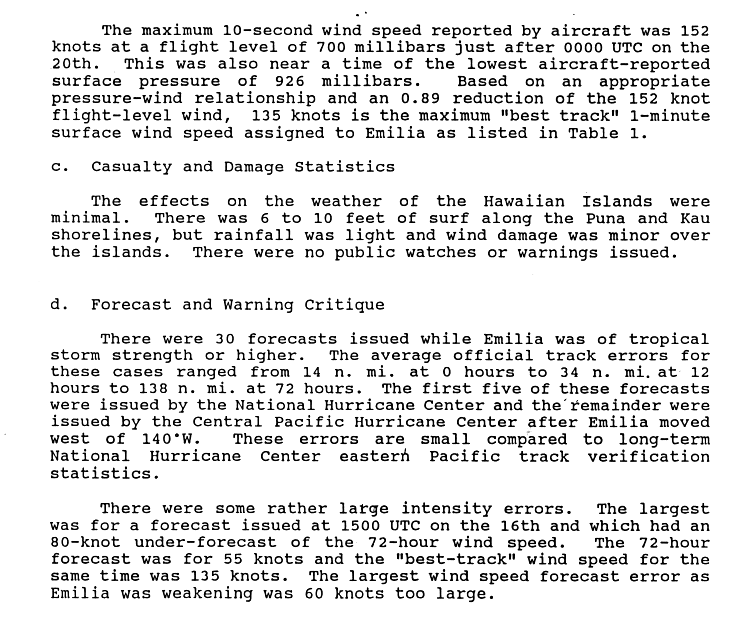
After reaching hurricane intensity the following day,the tropical cyclone underwent rapid intensification,and late on July19,Emilia reached its record peak intensity with maximum sustained winds of 160mph (260km/h) and a minimum barometric pressure of 926mbar (926hPa;27.3inHg),rating it as a Category5 hurricane. After slight oscillations in strength,an upper-level trough forced the intense hurricane northwest on July21,and Emilia began to weaken thereafter. The tropical cyclone encountered an area of vertical wind shear and cool sea surface temperatures,which further weakened the system. The following day,Emilia made its closest approach to the Big Island of Hawaii but subsequently weakened to below hurricane intensity. This weakening trend continued,and the tropical cyclone fully dissipated on July25. Though the hurricane did not make landfall,Emilia brought strong surf to the Hawaiian Islands and caused gusty winds,which resulted in some property damage. Precipitation was also reported but remained under moderate levels.
Meteorological history
Map plotting the storm's track and intensity,according to the Saffir–Simpson scale
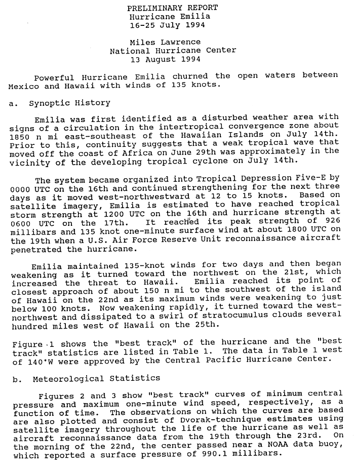
On June29, a weak tropical wave exited the west African coast and traversed the Atlantic, showing no signs of organization or convective activity. Moving within the Intertropical Convergence Zone, the tropical disturbance remained inactive until July14, when it developed into an area of low pressure roughly 2,110mi (3,400km) east-southeast of the Hawaiian Islands. A low-level circulation became evident, and the system was designated as a tropical depression on July 16. Within 12 hours, satellite imagery suggested that the system had intensified into Tropical Storm Emilia with 40mph (64km/h)sustained winds.[1][2] Emilia steadily intensified into a minimal hurricane by the next morning, as it moved west-northwest.[2] At 18:00 UTC, Emilia was upgraded to Category 2 status as it crossed 140°W and entered the Central Pacific Hurricane Center's (CPHC) area of responsibility, which noted that Emilia was "well developed."[3] Emilia then proceeded to rapidly intensify, with maximum sustained winds increasing from 105 to 160mph (169 to 257km/h) over the next 48 hours.[2][3] At Emilia's peak strength, an Air Force reconnaissance aircraft measured a minimum central pressure of 926 millibars (27.3inHg), the lowest pressure ever recorded in a Central Pacific hurricane at that time.[4][nb 1]
Oblique view from orbit
On July 20, Emilia briefly weakened into a Category4 hurricane, but it was re-upgraded to Category5 status by the CPHC 12hours later during the day.[3] Emilia became a Category5 hurricane for 18hours, the most ever at the time in the Central Pacific.[5] Subsequently, Emilia began to weaken for the final time. An upper-level trough in the westerlies caused the cyclone to turn northwest on July 21.[3][4] Emilia moved over progressively cooler waters, and vertical wind shear from the westerlies negatively impacted the hurricane.[3] The central pressure steadily rose to 965 millibars (28.5inHg), and Emilia diminished into a marginal Category3 hurricane.[3] On July 22, Emilia continued to weaken, and it passed within 170mi (270km) of the Big Island.[4] It was the closest approach to the islands.[4] Later, Emilia's peak winds dropped to 75mph (121km/h).[3] Emilia gradually turned west-northwest, and the circulation moved with the trade winds.[4] Emilia weakened into a tropical depression on July 24,[3] and a remnant swirl of stratocumulus clouds was noted.[4] The system dissipated on the same day.[3][6]
Intensity
The storm was the subject of a disagreement between the Central Pacific Hurricane Center and the National Hurricane Center. Specifically, they debated Emilia's peak strength in relation to the Saffir-Simpson hurricane scale (SSHWS). The CPHC reported that Emilia's maximum winds peaked at 140 knots (260km/h), making it a Category5 hurricane.[3] However, the NHC considered Emilia to be a high-end Category4 with maximum winds of 135 knots (250km/h), in both its "best track"[7] and its preliminary report.[8] During 2008, the NHC upgraded its "best track" to make Emilia a Category5, although there continues to be a discrepancy in Emilia's duration at Category 5 intensity. The CPHC's data deems Emilia as having regained Category 5 status at 18:00 UTC July 20 and maintaining it for 12 hours, while the NHC's data places Emilia as having maintained Category 4-strength winds of 155mph (249km/h) during this period.[2][3]
Preparations and impact
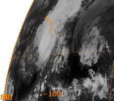
Emilia passing to the south of Hawaii on July 22
While Emilia passed south of Hawaii, swells of 6–10 feet (1.8–3.0 metres) were reported near the Puna and Ka‘ū coasts.[9]Waikiki Beach in Honolulu reported a 5ft (1.5m) high surf. Surf was lower along the Kona and Kohala coasts.[3][10] Winds were gusty, causing a few trees to be blown over and branches to be broken. Some minor roof damage was caused by the winds.[3]International observatories and the Keck Telescope on the top of Mauna Kea were forced to close their domes due to the high winds.[11]Rainfall ranged from light to moderate.[3]
↑The Central Pacific Hurricane Center (CPHC) lists Emilia as a Category 5 cyclone, but the National Hurricane Center (NHC) classified Emilia as a strong Category4 hurricane with 155mph (249km/h) sustained winds. However, in 2008, the NHC upgraded the storm into a Category 5 hurricane for 6 hours.[2]
This page is based on this Wikipedia article Text is available under the CC BY-SA 4.0 license; additional terms may apply. Images, videos and audio are available under their respective licenses.


