Martha's Vineyard is an island located south of Cape Cod in Massachusetts in the United States in North America that is known for being a popular summer colony. Martha's Vineyard includes the smaller adjacent Chappaquiddick Island, which is usually connected to the Vineyard, though storms and hurricanes have separated them, as of 2007. It is the 58th largest island in the United States, with a land area of about 96 square miles (250 km2), and the third-largest on the East Coast of the United States, after Long Island and Mount Desert Island. Martha's Vineyard constitutes the bulk of Dukes County, Massachusetts, which also includes the Elizabeth Islands and the island of Nomans Land.
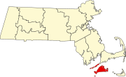
Dukes County is a county located in the U.S. state of Massachusetts. As of the 2010 census, the population was 16,535, making it the second-least populous county in Massachusetts. Its county seat is Edgartown.

Aquinnah is a town located on the western-end of Martha's Vineyard island, Massachusetts. From 1870 to 1997, the town was incorporated as Gay Head. In the 2010 U.S. census, the population was 311. Aquinnah is known for its beautiful clay cliffs and natural serenity, as well as its historical importance to the native Wampanoag people. In 1965, Gay Head Cliffs were designated as a National Natural Landmark by the National Park Service.
Chilmark is a town located on Martha's Vineyard in Dukes County, Massachusetts, United States. The population was 866 at the 2010 census. The fishing village of Menemsha is located on the western side of the town along its border with the town of Aquinnah. Chilmark had the highest median home sale price of any town or city in Massachusetts in 2013.
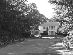
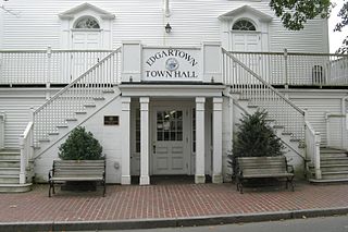
Edgartown is a tourist destination on the island of Martha's Vineyard in Dukes County, Massachusetts, United States, for which it is the county seat.

Oak Bluffs is a town located on the island of Martha's Vineyard in Dukes County, Massachusetts, United States. The population was 4,527 at the 2010 United States Census. It is one of the island's principal points of arrival for summer tourists, and is noted for its "gingerbread cottages" and other well-preserved mid- to late-nineteenth-century buildings. The town has been a historically important center of African American culture since the eighteenth century.
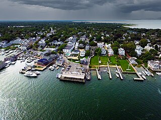
Tisbury is a town located on Martha's Vineyard in Dukes County, Massachusetts, United States. The population was 3,949 at the 2010 census.

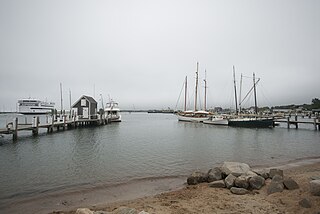
Vineyard Haven is a community within the town of Tisbury, Massachusetts on the island of Martha's Vineyard. It is listed as a census-designated place (CDP) by the U.S. Census Bureau with a population of 2,114 as of the 2010 census.

West Tisbury is a town located on Martha's Vineyard in Dukes County, Massachusetts, United States. The population was 2,740 at the 2010 census. Along with Chilmark and Aquinnah, West Tisbury forms "Up-Island" Martha's Vineyard.

Chappaquiddick Island, a part of the town of Edgartown, Massachusetts, is a small peninsula and occasional island on the eastern end of Martha's Vineyard. Norton Point, a narrow barrier beach, connects Martha's Vineyard and Chappaquiddick between Katama and Wasque. Occasional breaches occur due to hurricanes and strong storms separating the islands for periods of time. Most recently, the two were separated for 8 years from 2007 to 2015. While both land forms have mostly been connected to one another in modern history, Chappaquiddick is nevertheless referred to as an island.

Nomans Land, is an uninhabited island 612 acres (248 ha) in size, located in the town of Chilmark, Dukes County, Massachusetts. It is situated about 3 miles (4.8 km) off the southwest corner of the island of Martha's Vineyard.

The Woods Hole, Martha's Vineyard and Nantucket Steamship Authority, doing business as The Steamship Authority (SSA), is the statutory regulatory body for all ferry operations between mainland Massachusetts and the islands of Martha's Vineyard and Nantucket, as well an operator of ferry services between the mainland and the islands. It is the only ferry operator to carry automobiles to and from the islands. The Authority also operates several freight vessels, thus serving as the main link for shipping any commercial goods that are not transported using the airports on Nantucket or Martha's Vineyard.

The Flying Horses Carousel is the oldest operating platform carousel in America. Located in the historic resort community of Oak Bluffs, Massachusetts, on Martha's Vineyard, the carousel was apparently first located in New York City before being moved to the island in the 1880s.

West Chop Light is a lighthouse station located at the entrance of Vineyard Haven Harbor in Tisbury, Massachusetts on the northern tip of West Chop, a few miles from the village of Vineyard Haven.

The Nantucket was a sidewheel steamer operating as a ferry serving the islands of Martha's Vineyard and Nantucket during the end of the nineteenth century and the beginning of the twentieth century. On the Vineyard it docked at Cottage City, Vineyard Haven, and the West Chop Wharf.

Monohansett was a sidewheel steamer operating as a ferry serving the island of Martha's Vineyard during the late nineteenth century. She was named after Monohansett Island, a tiny 12-acre (4.9-hectare) island off Naushon Island.
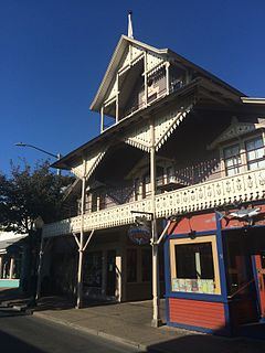
The Arcade is an historic building at 31 Circuit Avenue in Oak Bluffs, Massachusetts. Built in the early 1870s, it is one of the best preserved buildings on Circuit Ave, and is further locally significant as housing the offices of the Oak Bluffs Land and Wharf Company, which was responsible for much of the early development of the town of Oak Bluffs. The property was listed on the National Register of Historic Places in 1994.

East Chop Light is a historic lighthouse standing on a bluff overlooking Vineyard Haven Harbor and Vineyard Sound, located along East Chop Drive in the town of Oak Bluffs, Massachusetts. It is one of five lighthouses located on the island of Martha's Vineyard.
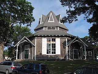
Union Chapel is an historic octagon-shaped church building in Oak Bluffs, on Martha's Vineyard, Massachusetts. The church was built in 1870 as a non-sectarian worship space in an area dominated by the Methodist summer camp meeting known as Wesleyan Grove. Acquired in 2002 by the nonprofit Martha's Vineyard Preservation Trust, the building continues to be used for nonsectarian religious services, and also serves as a community center and performing arts space.

Oak Bluffs is a census-designated place (CDP) in the town of Oak Bluffs, Dukes County, Massachusetts, United States, on the island of Martha's Vineyard. The Oak Bluffs CDP comprises the most densely settled part of the town, including the neighborhoods of Vineyard Highlands, Harthaven, and part of Eastville.