Denmark, Kansas | |
|---|---|
 | |
 Denmark  Denmark | |
| Coordinates: 39°05′21″N98°17′13″W / 39.08917°N 98.28694°W [1] | |
| Country | United States |
| State | Kansas |
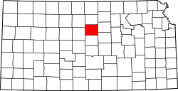
| County | Lincoln |
| Elevation | 1,411 ft (430 m) |
| Time zone | UTC-6 (CST) |
| • Summer (DST) | UTC-5 (CDT) |
| FIPS code | 20-17650 [1] |
| GNIS ID | 472547 [1] |
Denmark is an unincorporated community in Lincoln County, Kansas, United States. [1] It is northwest of Lincoln, and located three miles north of K-18.