Corinth, North Dakota | |
|---|---|
 Corinth, North Dakota  Corinth, North Dakota | |
| Coordinates: 48°36′45″N103°19′40″W / 48.61250°N 103.32778°W | |
| Country | United States |
| State | North Dakota |
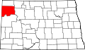
| County | Williams |
| Elevation | 2,205 ft (672 m) |
| Time zone | UTC-6 (Central (CST)) |
| • Summer (DST) | UTC-5 (CDT) |
| Area code | 701 |
| GNIS feature ID | 1028456 [1] |
Corinth is an unincorporated community in Williams County, North Dakota, United States. North Dakota Highway 42 runs along the eastern side of the community. [1]