Cooperstown, Illinois | |
|---|---|
 Cooperstown, Illinois  Cooperstown, Illinois | |
| Coordinates: 39°57′50″N90°36′23″W / 39.96389°N 90.60639°W | |
| Country | United States |
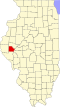
| State | Illinois |
| County | Brown |
| Elevation | 633 ft (193 m) |
| Time zone | UTC-6 (Central (CST)) |
| • Summer (DST) | UTC-5 (CDT) |
| Area code | 217 |
| GNIS feature ID | 406561 [1] |
Cooperstown is an unincorporated community in Brown County, Illinois, United States. [2] It is located east of Mount Sterling and southeast of Ripley.
William H. Dieterich, member of the Illinois House of Representatives, U.S. Representative from Illinois, and U.S. Senator from Illinois, was born near Cooperstown.[ citation needed ]