Clay Village | |
|---|---|
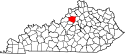
 Clay Village Location within the state of Kentucky  Clay Village Clay Village (the United States) | |
| Coordinates: 38°11′33″N85°6′26″W / 38.19250°N 85.10722°W | |
| Country | United States |
| State | Kentucky |
| County | Shelby |
| Elevation | 909 ft (277 m) |
| Time zone | UTC-5 (Eastern (EST)) |
| • Summer (DST) | UTC-4 (EDT) |
| GNIS feature ID | 489586 [1] |
Clay Village is an unincorporated community within Shelby County, Kentucky, United States. It was also known as Shytown. Their post office [2] is closed.