Cedar Grove, Henderson County, Tennessee | |
|---|---|
 Cedar Grove  Cedar Grove | |
| Coordinates: 35°28′55″N88°16′04″W / 35.48194°N 88.26778°W | |
| Country | United States |
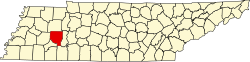
| State | Tennessee |
| County | Henderson |
| Elevation | 486 ft (148 m) |
| Time zone | UTC-6 (Central (CST)) |
| • Summer (DST) | UTC-5 (CDT) |
| Area code | 731 |
| GNIS feature ID | 1280027 [1] |
Cedar Grove is an unincorporated community in Henderson County, Tennessee, United States. [1] Cedar Grove is located on Tennessee State Route 104, northwest of Lexington. [2]