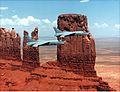
英文互译镜像站

Castle Rock (San Juan County, Utah)

Last updated

Castle Rock
Monument Valley - Castle Rock.jpg
Northeast aspect, centered
(Stagecoach to the right)
Highest point
Elevation 6,340 ft (1,932 m) [1]
Prominence 520 ft (158 m) [1]
Parent peak Brighams Tomb (6,739 ft) [1]
Isolation 1.1 mi (1.8 km) [1]
Coordinates 37°01′57″N110°04′27″W / 37.0325583°N 110.0742867°W / 37.0325583; -110.0742867 [2]
Geography
USA Utah relief location map.svg
Red triangle with thick white border.svg
Castle Rock
Location in Utah
Usa edcp relief location map.png
Red triangle with thick white border.svg
Castle Rock
Castle Rock (the United States)
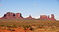
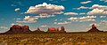
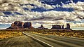
Location Monument Valley
San Juan County, Utah, U.S.
Parent range Colorado Plateau [3]
Topo map USGS Monument Pass
Geology
Mountain type Butte
Rock type Sandstone
Climbing
First ascent 1960
Easiest route class 5.10 climbing [1]

Castle Rock is a 6,340-foot-elevation (1,932-meter) summit in San Juan County, Utah, United States. [2]

Contents

Description

Castle Rock is situated four miles (6.4 km) north-northeast of the Monument Valley Tribal Park Visitor Center, on Navajo Nation land. It is an iconic landform of Monument Valley and can be seen from Highway 163. Precipitation runoff from this landform's slopes drains into the San Juan River drainage basin. [3] Topographic relief is significant as the summit rises 800 feet (244 meters) above the surrounding terrain in 0.25 mile (0.4 km). This landform's toponym has been officially adopted by the United States Board on Geographic Names. [2] It is so named because the butte resembles the silhouette of a castle. [4] The first ascent of the summit was made on May 8, 1960, by Harvey T. Carter, Layton Kor, and John Auld. [5] [6]

Geology

Castle Rock is composed of three principal strata. The bottom layer is slope-forming Organ Rock Shale, the next stratum is cliff-forming De Chelly Sandstone, and the upper layer is Moenkopi Formation. The rock ranges in age from Permian at the bottom to Triassic at the top. The buttes and mesas of Monument Valley are the result of the Organ Rock Shale being more easily eroded than the overlaying sandstone. [7]

Climate

Spring and fall are the most favorable seasons to visit Castle Rock. According to the Köppen climate classification system, it is located in a semi-arid climate zone with cold winters and hot summers. Summers average 54 days above 90 °F (32 °C) annually, and highs rarely exceed 100 °F (38 °C). Summer nights are comfortably cool, and temperatures drop quickly after sunset. Winters are cold, but daytime highs are usually above freezing. Winter temperatures below 0 °F (−18 °C) are uncommon, though possible. This desert climate receives less than 10 inches (250 millimeters) of annual rainfall, and snowfall is generally light during the winter. [8]

See also

References

  1. 1 2 3 4 5 "Castle Rock - 6,340' UT". listsofjohn.com. Retrieved August 28, 2024.
  2. 1 2 3 "Castle Rock". Geographic Names Information System . United States Geological Survey, United States Department of the Interior . Retrieved August 28, 2024.
  3. 1 2 "Castle Rock, Utah". Peakbagger.com. Retrieved August 28, 2024.
  4. Monument Valley, City of Aztec, aztecnm.com, Retrieved 2024-08-28.
  5. First Ascent Timeline, deserttowersbook.com, Retrieved 2024-08-28.
  6. Layton Kor, Beyond the Vertical, Rowman & Littlefield, 2013, ISBN   9781493001323, p. 57.
  7. Monument Valley, Arizona, Arizona Geological Survey, Retrieved 2024-08-24.
  8. Climate Summary for Kayenta, Arizona


小偷程序 镜像精灵 递归网站下载 泛域名镜像 镜像精灵