Blanchard, North Dakota | |
|---|---|
 Blanchard residential street | |
 Blanchard, North Dakota Location within the state of North Dakota | |
| Coordinates: 47°20′35″N097°13′23″W / 47.34306°N 97.22306°W | |
| Country | |
| State | |
| County | Traill |
| Area | |
• Total | 0.25 sq mi (0.66 km2) |
| • Land | 0.25 sq mi (0.66 km2) |
| • Water | 0 sq mi (0.00 km2) |
| Elevation | 945 ft (288 m) |
| Population (2020) | |
• Total | 16 |
| • Density | 62.8/sq mi (24.25/km2) |
| Time zone | UTC-6 (Central (CST)) |
| • Summer (DST) | UTC-5 (CDT) |
| ZIP code | 58009 |
| Area code | 701 |
| FIPS code | 38-07620 [3] |
| GNIS feature ID | 2584337 [2] |
Blanchard is a census-designated place in Blanchard Township, Traill County, North Dakota, United States. The population was 16 at the 2020 census. [4]
Contents
Blanchard is near the North Dakota-Minnesota border, near the junction of state highways 18 and 200.
The KVLY-TV mast was the tallest man-made structure in the Western Hemisphere until 2019. It stands near Blanchard. The mast is used to transmit television broadcasts from the Fargo station KVLY-TV and was the tallest man-made structure in the world from 1963 to 1974 and again from 1991 to 2008. Similarly, the KRDK-TV mast, the tallest man-made structure in the United States, stands 6 miles (9.7 km) from Blanchard, near Galesburg.
 Blanchard post office
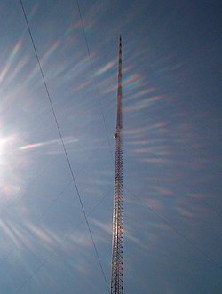 KVLY-TV mast seen close-up


