Avillers-Sainte-Croix | |
|---|---|
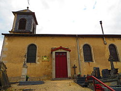 The church in Avillers-Sainte-Croix | |
 Location of Avillers-Sainte-Croix | |
 Avillers-Sainte-Croix  Avillers-Sainte-Croix | |
| Coordinates: 49°01′57″N5°42′02″E / 49.0325°N 5.7006°E | |
| Country | France |
| Region | Grand Est |
| Department | Meuse |
| Arrondissement | Verdun |
| Canton | Étain |
| Intercommunality | CC Territoire Fresnes-en-Woëvre |
| Government | |
| • Mayor (2020–2026) | François Jamin [1] |
Area 1 | 5.5 km2 (2.1 sq mi) |
| Population (2023) [2] | 80 |
| • Density | 15/km2 (38/sq mi) |
| Time zone | UTC+01:00 (CET) |
| • Summer (DST) | UTC+02:00 (CEST) |
| INSEE/Postal code | 55021 /55210 |
| Elevation | 212–239 m (696–784 ft) (avg. 203 m or 666 ft) |
| 1 French Land Register data, which excludes lakes, ponds, glaciers > 1 km2 (0.386 sq mi or 247 acres) and river estuaries. | |
Avillers-Sainte-Croix is a commune in the Meuse department in the Grand Est region in northeastern France.