Alvaton | |
|---|---|
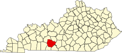
 Alvaton Location within the state of Kentucky  Alvaton Alvaton (the United States) | |
| Coordinates: 36°52′24″N86°21′11″W / 36.87333°N 86.35306°W | |
| Country | United States |
| State | Kentucky |
| County | Warren |
| Elevation | 663 ft (202 m) |
| Time zone | UTC-6 (Central (CST)) |
| • Summer (DST) | UTC-5 (CDT) |
| ZIP codes | 42122 |
| GNIS feature ID | 485916 [1] |
Alvaton is an unincorporated community in Warren County, Kentucky, United States. It is 9.5 miles southeast of Bowling Green, Kentucky on U.S. Route 231. [2] It is home to Alvaton Elementary School, which is part of the Warren County Public Schools system.