Related Research Articles

Lewis Township is a township in Lycoming County, Pennsylvania, United States. The population was 987 at the 2010 census, down from 1,139 in 2000. It is part of the Williamsport Metropolitan Statistical Area.

Washington Township is a township in Lycoming County, Pennsylvania, United States. The population was 1,769 at the 2020 census. It is part of the Williamsport Metropolitan Statistical Area.

The Kittanning Path was a major east-west Native American trail that crossed the Allegheny Mountains barrier ridge connecting the Susquehanna River valleys in the center of Pennsylvania to the highlands of the Appalachian Plateau and thence to the western lands beyond drained by the Ohio River. Kittanning Village was the first major Delaware (Lenape) Indian settlement along the descent from the Allegheny Plateau.

The Juniata River is a tributary of the Susquehanna River, approximately 104 miles (167 km) long, in central Pennsylvania. The river is considered scenic along much of its route, having a broad and shallow course passing through several mountain ridges and steeply lined water gaps. It formed an early 18th-century frontier region in Pennsylvania and was the site of French-allied Native American attacks against English colonial settlements during the French and Indian War.


The Wyalusing Path or trail was a historical trace that ran from what is now Wyalusing to the Native American village of Canaserage in Pennsylvania in the United States. Wyalusing is on the east bank of the North Branch of the Susquehanna River in Bradford County and Muncy is on the east bank of the West Branch Susquehanna River in Lycoming County, so the path provided a short cut between the two main branches of the Susquehanna River. The alternative and much longer route was to follow the North Branch south from Wyalusing to the confluence with the West Branch at the Native village of Shamokin, then north up the West Branch to Muncy.

White Deer Hole Creek is a 20.5-mile (33.0 km) tributary of the West Branch Susquehanna River in Clinton, Lycoming and Union counties in the U.S. state of Pennsylvania. A part of the Chesapeake Bay drainage basin, the White Deer Hole Creek watershed drains parts of ten townships. The creek flows east in a valley of the Ridge-and-valley Appalachians, through sandstone, limestone, and shale from the Ordovician, Silurian, and Devonian periods.

Anderson Creek is a 23.6-mile-long (38.0 km) tributary of the West Branch Susquehanna River in Clearfield County, Pennsylvania, in the United States.

The Great Island Path was a major Native American trail in the U.S. state of Pennsylvania that ran from the village of Shamokin along the right bank of the West Branch Susquehanna River north and then west to the Great Island.
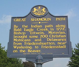
The Great Shamokin Path was a major Native American trail in the U.S. State of Pennsylvania that ran from the native village of Shamokin along the left bank of the West Branch Susquehanna River north and then west to the Great Island. There it left the river and continued further west to Chinklacamoose and finally Kittanning on the Allegheny River.
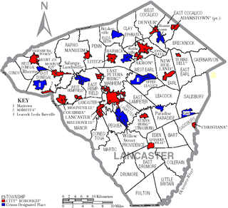
Transportation in Lancaster County, Pennsylvania has a long and variegated history. An early-settled part of the United States, and lying on the route between Philadelphia and Harrisburg, it has been the site of early experiments in canals, railroads, and highways. Before all these, at least ten Native American paths crossed parts of the county, many connecting with the Susquehannock village of Conestoga.

The Great Indian Warpath (GIW)—also known as the Great Indian War and Trading Path, or the Seneca Trail—was that part of the network of trails in eastern North America developed and used by Native Americans which ran through the Great Appalachian Valley. The system of footpaths extended from what is now upper New York to deep within Alabama. Various Native peoples traded and made war along the trails, including the Catawba, numerous Algonquian tribes, the Cherokee, and the Iroquois Confederacy. The British traders' name for the route was derived from combining its name among the northeastern Algonquian tribes, Mishimayagat or "Great Trail", with that of the Shawnee and Delaware, Athawominee or "Path where they go armed".
The Sheshequin Path was a major Native American trail in the U.S. State of Pennsylvania that ran between two Native American villages: "French Margaret's Town" on the West Branch Susquehanna River and "Sheshequin" on the North Branch of the Susquehanna River. The path ran north and east along Lycoming Creek in Lycoming County and followed much of Towanda Creek in Bradford County. It was a shortcut between the two main branches of the Susquehanna River and was used by early settlers as well as Native Americans.


The Big Runaway was a mass evacuation in June and July 1778 of settlers from the frontier areas of north central Pennsylvania during the American Revolutionary War. A major campaign by Loyalists and Native Americans allied with the British devastated the small communities on the northern and western branches of the Susquehanna River, prompting local militia leaders to order the evacuation. Most of the settlers relocated to Fort Augusta at modern-day Sunbury at the confluence of the North and West Branches of the Susquehanna River, while their abandoned houses and farms were all burnt.
Honey Creek is a 20.3-mile-long (32.7 km) tributary of Kishacoquillas Creek that is located in Mifflin County, Pennsylvania in the United States.
Kishacoquillas Creek is a 24.0-mile-long (38.6 km) tributary of the Juniata River in Mifflin County, Pennsylvania in the United States.
Jacks Mountain is a stratigraphic ridge which is located in central Pennsylvania, United States, trending southeast of the Stone Mountain ridge and Jacks Mountain Anticline. The ridge line separates Kishacoquillas Valley from the Ferguson and Dry Valleys.

The Pine Creek Path was a major Native American trail in the U.S. State of Pennsylvania that ran north along Pine Creek from the West Branch Susquehanna River near Long Island to the headwaters of the Genesee River.

The Bald Eagle Creek Path was a major Native American trail in the U.S. State of Pennsylvania that ran from the Great Island on the West Branch Susquehanna River southwest to what is now the village of Frankstown on the Frankstown Branch Juniata River. The path ran from Clinton County southwest through Centre County and a small part of Blair County to its southern end in Blair County. It was part of a "Warriors Path", an important connector between paths leading to New York and the Six Nations of the Iroquois and the Ohio River country in the north and west, and paths leading to what are now Maryland, Virginia, and the Carolinas in the south.
References
- ↑ Wallace, Paul A.W. (1987). Indian Paths of Pennsylvania (Fourth Printing ed.). Harrisburg, Pennsylvania: Pennsylvania Historical and Museum Commission. pp. 91–92. ISBN 0-89271-090-X.
(Note: ISBN refers to 1998 impression.)
| | This United States trail or long-distance path–related article is a stub. You can help Wikipedia by expanding it. |