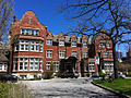
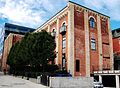
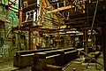
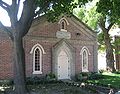
Name Address Coordinates Government recognition (CRHP № ) Image 1929 clubhouse of the Toronto Hunt Club Toronto ON 43°44′34″N 79°24′47″W / 43.7428°N 79.4131°W / 43.7428; -79.4131 (1929 clubhouse of the Toronto Hunt Club ) Federal (11502 ) More images 47 Front Street East Toronto ON 43°38′53″N 79°22′28″W / 43.6481°N 79.3745°W / 43.6481; -79.3745 (47 Front Street East ) Ontario (8837 ) More images 49 Front Street East (Dixon Building) Toronto ON 43°38′54″N 79°22′28″W / 43.6482°N 79.3745°W / 43.6482; -79.3745 (49 Front Street East (Dixon Building) ) Ontario (8838 ),1451 ) More images Annesley Hall at the University of Toronto Toronto ON 43°40′04″N 79°23′35″W / 43.667777777778°N 79.393055555556°W / 43.667777777778; -79.393055555556 (Annesley Hall University of Toronto ) Federal (1155 ) Q4769020 More images Armour Heights College Toronto ON 43°44′30″N 79°24′53″W / 43.7418°N 79.4148°W / 43.7418; -79.4148 (Armour Heights College ) Federal (7518 ) Upload Photo Jesse Ashbridge House Toronto ON 43°39′56″N 79°19′18″W / 43.6656°N 79.3218°W / 43.6656; -79.3218 (Jesse Ashbridge House ) Ontario (8869 ) More images Balmoral Fire Hall Toronto ON 43°41′08″N 79°23′41″W / 43.6855°N 79.3946°W / 43.6855; -79.3946 (Balmoral Fire Hall ) Federal (7371 ) More images Bank of Toronto Toronto ON 43°39′13″N 79°22′47″W / 43.6535°N 79.3797°W / 43.6535; -79.3797 (Bank of Toronto ) Ontario (8843 ),19828 ) More images Bank of Upper Canada Building Toronto ON 43°39′06″N 79°22′15″W / 43.6518°N 79.3709°W / 43.6518; -79.3709 (Bank of Upper Canada Building ) Federal (1776 ) More images Bead Hill National Historic Site of Canada Toronto (Scarborough) ON 43°48′20″N 79°08′10″W / 43.8056°N 79.1360°W / 43.8056; -79.1360 (Bead Hill National Historic Site of Canada ) Federal (16783 ) Upload Photo Birkbeck Building Toronto ON 43°39′03″N 79°22′40″W / 43.6507°N 79.3779°W / 43.6507; -79.3779 (Birkbeck Building ) Federal (7555 ), 19809 ) More images Chapel of St. James-the-Less Toronto ON 43°40′11″N 79°22′10″W / 43.6696°N 79.3694°W / 43.6696; -79.3694 (Chapel of St. James-the-Less ) Federal (7487 ) More images Dominion Public Building Toronto ON 43°38′46″N 79°22′41″W / 43.6462°N 79.3781°W / 43.6462; -79.3781 (Dominion Public Building ) Federal (18075 ) More images Don Brewery 43°39′28″N 79°21′25″W / 43.6578°N 79.3569°W / 43.6578; -79.3569 (Don Brewery ) Toronto municipality (1321 ) Q17104966 More images Don Valley Brick Works Toronto ON 43°41′11″N 79°21′46″W / 43.6863°N 79.3628°W / 43.6863; -79.3628 (Don Valley Brick Works ) Ontario (15361 ) More images Eaton's 7th Floor Auditorium and Round Room Toronto ON 43°39′41″N 79°23′01″W / 43.6614°N 79.3835°W / 43.6614; -79.3835 (Eaton's 7th Floor Auditorium and Round Room ) Federal (7413 ) More images Eglinton Theatre Toronto ON 43°42′15″N 79°24′38″W / 43.7043°N 79.4105°W / 43.7043; -79.4105 (Eglinton Theatre ) Federal (12689 ) More images Elgin and Winter Garden Theatres Toronto ON 43°39′11″N 79°22′45″W / 43.6531°N 79.3793°W / 43.6531; -79.3793 (Elgin and Winter Garden Theatres ) Federal (11960 ), 9622 ) More images Enoch Turner Schoolhouse Toronto ON 43°39′11″N 79°21′41″W / 43.6530°N 79.3613°W / 43.6530; -79.3613 (Enoch Turner Schoolhouse ) Ontario (19803 ) More images Fourth York Post Office Toronto ON 43°39′06″N 79°22′13″W / 43.6518°N 79.3704°W / 43.6518; -79.3704 (Fourth York Post Office ) Federal (12726 ) More images Fort York Heritage Conservation District Toronto ON 43°38′21″N 79°24′10″W / 43.6391°N 79.4029°W / 43.6391; -79.4029 (Fort York Heritage Conservation District ) Toronto municipality (3567 ) Fort York Armoury Toronto ON 43°38′13″N 79°24′29″W / 43.637°N 79.408°W / 43.637; -79.408 (Fort York Armoury ) Federal (9693 ) More images Fort York Toronto ON 43°38′18″N 79°24′21″W / 43.6383°N 79.4057°W / 43.6383; -79.4057 (Fort York ) Federal (3677 ) More images George Brown House Toronto ON 43°39′21″N 79°23′41″W / 43.6559°N 79.3948°W / 43.6559; -79.3948 (George Brown House ) Federal (9182 ), 8868 ) More images Gooderham and Worts Distillery Toronto ON 43°39′01″N 79°21′33″W / 43.6504°N 79.3592°W / 43.6504; -79.3592 (Gooderham and Worts Distillery ) Federal (1195 ) More images Gooderham Building Toronto ON 43°38′54″N 79°22′28″W / 43.6483°N 79.3745°W / 43.6483; -79.3745 (Gooderham Building ) Ontario (8311 ) More images Gouinlock Buildings / Early Exhibition Buildings National Historic Site of Canada Toronto ON 43°37′43″N 79°24′42″W / 43.6285°N 79.4118°W / 43.6285; -79.4118 (Gouinlock Buildings / Early Exhibition Buildings National Historic Site of Canada ) Federal (10470 ) More images Heliconian Hall Toronto ON 43°40′18″N 79°23′36″W / 43.6717°N 79.3934°W / 43.6717; -79.3934 (Heliconian Hall ) Federal (13819 ) More images John Street Roundhouse Toronto ON 43°38′28″N 79°23′10″W / 43.641°N 79.386°W / 43.641; -79.386 (John Street Roundhouse ) Federal (12781 ) More images Joseph Sheppard Building Toronto ON 43°45′47″N 79°24′47″W / 43.763°N 79.413°W / 43.763; -79.413 (Joseph Sheppard Building ) Federal (10230 ) More images Kensington Market Toronto ON 43°39′15″N 79°24′04″W / 43.6542°N 79.4011°W / 43.6542; -79.4011 (Kensington Market ) Federal (14463 ) More images Maple Leaf Gardens Toronto ON 43°39′44″N 79°22′49″W / 43.6621°N 79.3804°W / 43.6621; -79.3804 (Maple Leaf Gardens ) Federal (13397 ) More images Mary Perram House Toronto ON 43°40′02″N 79°22′37″W / 43.6671°N 79.3770°W / 43.6671; -79.3770 (Mary Perram House ) Toronto municipality (1439 ) More images Masaryk Hall Toronto ON 43°38′28″N 79°25′58″W / 43.6411°N 79.4329°W / 43.6411; -79.4329 (Masaryk Hall ) Ontario (10512 ) More images Massey Hall Toronto ON 43°39′15″N 79°22′45″W / 43.6543°N 79.3791°W / 43.6543; -79.3791 (Massey Hall ) Federal (9369 ) More images Montgomery's Tavern Toronto ON 43°42′34″N 79°23′57″W / 43.7094°N 79.3992°W / 43.7094; -79.3992 (Montgomery's Tavern ) Federal (14414 ) Mount Pleasant Cemetery Toronto ON 43°41′46″N 79°23′03″W / 43.696°N 79.3843°W / 43.696; -79.3843 (Mount Pleasant Cemetery ) Federal (9514 ) More images Newman Centre Toronto ON 43°39′51″N 79°23′54″W / 43.6642°N 79.3983°W / 43.6642; -79.3983 (Newman Centre ) Ontario (10539 ) More images Old Toronto City Hall and York County Court House Toronto ON 43°39′09″N 79°22′55″W / 43.6526°N 79.382°W / 43.6526; -79.382 (Old Toronto City Hall and York County Court House ) Federal (4255 ) More images Osgoode Hall Toronto ON 43°39′07″N 79°23′08″W / 43.6519°N 79.3856°W / 43.6519; -79.3856 (Osgoode Hall ) Federal (4258 ) More images St. Anne's Anglican Church Toronto ON 43°39′02″N 79°25′51″W / 43.6505°N 79.4307°W / 43.6505; -79.4307 (St. Anne's Anglican Church ) Federal (12681 ), 8901 ) More images Postal Station "D" Toronto ON 43°39′50″N 79°27′50″W / 43.664°N 79.464°W / 43.664; -79.464 (Postal Station "D" ) Federal (4686 ) More images Royal Alexandra Theatre Toronto ON 43°38′50″N 79°23′15″W / 43.6471°N 79.3876°W / 43.6471; -79.3876 (Royal Alexandra Theatre ) Federal (1137 ) More images Rupert Simpson House and Stable Toronto ONToronto municipality (1291 ) More images St. George's Hall (Arts and Letters Club) Toronto ON 43°39′28″N 79°22′57″W / 43.6578°N 79.3825°W / 43.6578; -79.3825 (St. George's Hall (Arts and Letters Club) ) Federal (12139 ) More images St. Lawrence Hall Toronto ON 43°39′00″N 79°22′20″W / 43.6501°N 79.3722°W / 43.6501; -79.3722 (St. Lawrence Hall ) Federal (7527 ) More images The Studio Building Toronto ON 43°40′24″N 79°23′10″W / 43.6732°N 79.3861°W / 43.6732; -79.3861 (The Studio Building ) Federal (9521 ) More images The Grange Toronto ON 43°39′14″N 79°23′37″W / 43.6538°N 79.3935°W / 43.6538; -79.3935 (The Grange ) Federal (7529 ) More images The Royal Conservatory of Music Toronto ON 43°40′05″N 79°23′46″W / 43.668°N 79.3962°W / 43.668; -79.3962 (The Royal Conservatory of Music ) Federal (12044 ) More images Toronto Island Airport Terminal Building Toronto ON 43°37′58″N 79°23′43″W / 43.6327°N 79.3953°W / 43.6327; -79.3953 (Toronto Island Airport Terminal Building ) Federal (7530 ) More images Toronto Street Post Office / Bank of Canada Building Toronto ON 43°38′59″N 79°22′34″W / 43.6498°N 79.3762°W / 43.6498; -79.3762 (Toronto Street Post Office / Bank of Canada Building ) Federal (9933 ) More images Union Station (Canadian Pacific Railway and Grand Trunk Railway ) Toronto ON 43°38′44″N 79°22′51″W / 43.6455°N 79.3808°W / 43.6455; -79.3808 (Union Station (Canadian Pacific Railway and Grand Trunk Railway) ) Federal (6299 ,6492 ) More images University College, Toronto University of Toronto Toronto ON 43°39′45″N 79°23′43″W / 43.6625°N 79.3954°W / 43.6625; -79.3954 (University College, Toronto ) Federal (9520 ) More images Wesley Building Toronto ON 43°38′52″N 79°23′28″W / 43.6479°N 79.391°W / 43.6479; -79.391 (Wesley Building ) Toronto municipality (4921 ) More images Winchester Hotel and Winchester Hall Toronto ON 43°39′56″N 79°22′06″W / 43.6656°N 79.3682°W / 43.6656; -79.3682 (Winchester Hotel and Winchester Hall ) Toronto municipality (3631 ) More images Women's College Hospital Toronto ON 43°39′42″N 79°23′15″W / 43.6617°N 79.3874°W / 43.6617; -79.3874 (Women's College Hospital ) Federal (7738 ) More images