
Cowichan IR No. 1
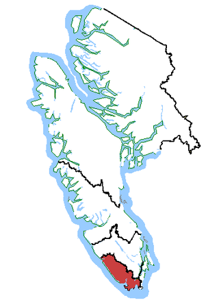
Location of Cowichan IR No. 1 in British Columbia
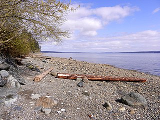
Cowichan Indian Reserve No. 1 is an Indigenous reserve in British Columbia, located south of the city of Duncan.
Cowichan Indian Reserve No. 1 is an Indigenous reserve in British Columbia, located south of the city of Duncan.
48°45′14″N123°34′34″W / 48.754°N 123.576°W
| | This article about a location on the Coast of British Columbia, Canada is a stub. You can help Wikipedia by expanding it. |

Duncan is a city on southern Vancouver Island in British Columbia, Canada. It is the smallest city by area in Canada. It was incorporated in 1912.

Cowichan Bay is a bay and community located on the east coast of southern Vancouver Island near Duncan, in British Columbia, Canada. The mouth of the Cowichan River is near Cowichan Bay. Mount Tzouhalem with its hiking trails and ecological reserve stands to the north. The bay is known for its fishing and scenic value. The area's main industries are fishing and tourism.
Saltair is an unincorporated community with a population of 2,325 on the east coast of Vancouver Island, British Columbia, Canada, or the Georgia Strait. It is a predominantly rural community located between the urban centers of Ladysmith and Chemainus. Saltair is within the Cowichan Valley Regional District. It is home to a number of parks: Stocking Creek Park, Diana, Princess of Wales Wilderness Park, and Saltair Centennial Park. In part, Saltair is a community of artists, scenery and farmland. It provides panoramic ocean and mountain views and a rural ambiance its residents treasure. Community news and updates can be found on Saltair websites. The area is served by the coast-spanning Island Highway and the Island Rail Corridor.
Esquimalt—Juan de Fuca is a former federal electoral district in the province of British Columbia, Canada, which was represented in the House of Commons of Canada from 1988 to 2015
Nanaimo was a federal electoral district in British Columbia, Canada, that was represented in the House of Commons of Canada from 1904 to 1979.
Juan de Fuca-Malahat is a provincial electoral district for the Legislative Assembly of British Columbia, Canada created by the 2021 British Columbia electoral redistribution that will come into effect in 2024. It has near-identical boundaries to the provincial electoral district of Malahat-Juan de Fuca in use from 1991 to 2009.

The Cowichan River is a Canadian Heritage River on Vancouver Island, in British Columbia, Canada. Its headwater is Cowichan Lake. The river flows east over Skutz Falls and through Marie Canyon towards its mouth at Cowichan Bay. The river's drainage basin is 795 square kilometres (307 sq mi) in size.

The BC Forest Discovery Centre, located in Duncan, chronicles the history of logging in British Columbia, Canada. It is a 100-acre (40 ha) site with 2.5 km of operational 3 ft narrow gauge railway.

Malahat is an unincorporated area in the Cowichan Valley, with municipal-type services delivered by the Cowichan Valley Regional District. What could be considered the hub of the community is a small collection of businesses that includes the Malahat Gas station and the Malahat Chalet and the Moon Water Lodge.
Westholme is a community located in the Chemainus River Valley alongside the Island Highway, between Chemainus and Duncan in British Columbia, Canada. It is part of the Chemainus Land District in the District Municipality of North Cowichan. Westholme is one of the original settlements on Vancouver Island. Once a thriving mining and farming community, it is now filled with hobby farms and upscale private estates on large acreages, many of which are owned to this day by the descendants of original settlers to this area.
Maple Bay is a seaside community located in the Cowichan Valley of southern Vancouver Island, British Columbia, Canada. A narrow inlet and surrounded by smooth, pebbled beaches, Maple Bay is home to marine activity all year round. Maple Bay is a small town with a population of 2,640.
Cobble Hill, occasionally and mistakenly referred to as Cobble Hill Mountain, is located in Cobble Hill, British Columbia. It is a major attraction for hikers and outdoor enthusiasts in the area. It is 336 meters in elevation, or 1102 feet. It is mostly covered in evergreen and maple trees, arbutus, and small amounts of brush where the hillside is not too steep. It also has a network of trails and paths running along the hillside in a switchback fashion to accommodate for the steep slopes. The majority of the hill is a regional park, and contains small picnic area, dog park, a dirt jump park at the base for bicycle riders, and picnic areas on both sides of the summit. From the top, there are views of the Cowichan Valley, Saanich Peninsula and Gulf Islands. The hill is mostly common rock, with a small amount of limestone and granite, and a layer of topsoil that is deep enough to support the large trees near and on the hill. The hill is within easy walking distance of the town centre and the nearby train and bus stations.
Cowichan Tribes is the band government of the Cowichan, a group of Coast Salish peoples who live in the Cowichan Valley region on Vancouver Island. With over 3,800 registered members, it is the single largest First Nations band in British Columbia.
Marie Canyon is a canyon on the Cowichan River, just below Skutz Falls, on southern Vancouver Island, British Columbia, Canada.
Skutz Falls is a waterfall on the Cowichan River on Vancouver Island, British Columbia, Canada. It is located just above Marie Canyon. The name was originally Skwets or Squitz, meaning "waterfall" in the Cowichan dialect of Halkomelem.
Sansum Narrows is a strait or channel between Vancouver Island (W) and Saltspring Island (E) in the Southern Gulf Islands region of British Columbia, Canada. The narrows are between Maple Bay and Tl’ulpalus.
The Tseycum First Nation is a First Nations government located on Vancouver Island. In the 1850s, they were signatories to the Douglas Treaties.

Cowichan was a steamship which was operated in British Columbia under the ownership of the Union Steamship Company. Cowichan sank in 1925 following a collision with another ship.
Koksilah is a community located just southeast of the City of Duncan, British Columbia, Canada. Its name is derived, via that of the Koksilah River, from that of the Hwulqwselu people, one of the Hǝn̓q̓ǝmin̓ǝm̓-speaking peoples of the area today organized as the Cowichan Tribes and government.

The Koksilah River is a river on Vancouver Island, British Columbia, Canada, flowing northeast to enter Cowichan Bay just southeast of the City of Duncan. Part of the river is protected as Koksilah River Provincial Park. It is the namesake of the community of Koksilah, which is just southeast of Duncan. Kinsol Trestle is built across the river.